 Filter: Categories of Wisconsin Historical Images
Filter: FULL_DATE of 1926
Filter: Subject of transportation
Filter: Categories of Wisconsin Historical Images
Filter: FULL_DATE of 1926
Filter: Subject of transportation

| Date: | 1926 |
|---|---|
| Description: | View of grounds with a large guest cottage with large front porch on the right. On the left is a three-story structure shaped like a tower. |

| Date: | 1926 |
|---|---|
| Description: | Men and boys fishing at Jordan Lake. One man is standing next to a boat pulled up at the shore and is holding up his catch of the day. There are cattails a... |

| Date: | 1926 |
|---|---|
| Description: | Exterior view of the Edgewater Hotel Anex [sic] which has a screened-in porch. Young trees are planted in the lawn. |
| Date: | 1926 |
|---|---|
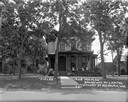
| Description: | View from street of a large brick house with an arched entrance and wrap-around columned porch. There are benches on the lawn along the side of the house o... |

| Date: | 1926 |
|---|---|
| Description: | Family of five standing in front of a small guest cottage with porch. There is an automobile parked on the left. |

| Date: | 1926 |
|---|---|
| Description: | The "Freeport" cottage at Oshawa Cottages. There is an entrance on the side of the screened-in porch. In the background on the left is another building, an... |

| Date: | 1926 |
|---|---|
| Description: | Elevated view of the Pine Grove Hotel and Resort from the opposite shore of the Wisconsin River. An excursion boat is passing by. Rock formations are along... |

| Date: | 1926 |
|---|---|
| Description: | Schofield Cottage Hotel and driveway with an automobile parked near the porte-cochere. There are striped awnings over the windows on both the first and sec... |

| Date: | 1926 |
|---|---|
| Description: | Screened-in porch side of Walmar Lodge. A bench is under the trees, and an automobile is parked on the left. |

| Date: | 1926 |
|---|---|
| Description: | Beach on the Wisconsin River. There is a group of bathers in the water, and a group of tourists on a nearby rock. A steamboat is passing by in the distance... |

| Date: | 1926 |
|---|---|
| Description: | This map is oriented with the north to the upper right and shows a plat of the area, numbered blocks, lots, and wards, land ownership by name, local street... |
| Date: | 1926 |
|---|---|
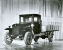
| Description: | Original caption reads: "International 'speed' trucks were introduced in 1921. They offered higher speeds to match road-development progress of the 1920's.... |

| Date: | 1926 |
|---|---|
| Description: | Florentina and Alexander Krueger posing in front of a Chevy Sedan. |

| Date: | 1926 |
|---|---|
| Description: | This map shows streets, railroads, parks, and cemeteries. The top right includes an advertisement for Bartles-Maguire Oil Co. Wards are colored in red, yel... |

| Date: | 1926 |
|---|---|
| Description: | This brochure was intended for tourists and shows resorts, lakes and railroads in northwestern Wisconsin and part of Michigan’s upper peninsula. Also inclu... |

| Date: | 1926 |
|---|---|
| Description: | Exterior view of the South Madison Chicago and North Western Railroad Station located next to the railroad tracks that cross Lakeside Street. In the foregr... |
| Date: | 1926 |
|---|---|
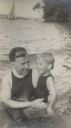
| Description: | William F. Petersen holds his son Conrad in the waters of Geneva Lake off the shore of Black Point. There are sailboats in the background. |
| Date: | 1926 |
|---|---|
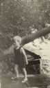
| Description: | Conrad Petersen steps off the pier onto the shore at Black Point Estate. A small boat is moored to the shore in the background under a tree trunk leaning ... |

| Date: | 1926 |
|---|---|
| Description: | This map shows the state trunk highway system and county trunk highways. The lower left corner includes a legend of roadway types. Lake Michigan and Lake S... |

| Date: | 1926 |
|---|---|
| Description: | This blueprint manuscript map shows buildings, railroads, and United States property. Water depths shown by soundings, tints, and isolines. |
If you didn't find the material you searched for, our Library Reference Staff can help.
Call our reference desk at 608-264-6535 or email us at: