 Filter: Categories of Wisconsin Historical Images
Filter: FULL_DATE of 1926
Filter: Subject of transportation
Filter: Subject of cities and towns
Filter: Categories of Wisconsin Historical Images
Filter: FULL_DATE of 1926
Filter: Subject of transportation
Filter: Subject of cities and towns

| Date: | 1926 |
|---|---|
| Description: | Map of the routes of the screw-driven passenger/freight vessels of the Michigan Transit Company for 1926. |
| Date: | 1926 |
|---|---|
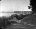
| Description: | Lake Mendota, including Fraternity Row and east side shoreline, taken from the lake path on University Bay Drive. |
| Date: | 1926 |
|---|---|
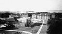
| Description: | View of Adams, Tripp and Van Hise Halls. All are residence halls on the University of Wisconsin campus with Picnic Point and Lake Mendota in the backgroun... |
| Date: | 1926 |
|---|---|
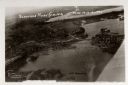
| Description: | Aerial view with Wisconsin River. Caption reads: "Schofield Home Coming June 16-17-18-1927". The wing of an airplane is in the right foreground. |
| Date: | 1926 |
|---|---|
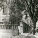
| Description: | View of the State Historical Society as seen from the sidewalk along Langdon Street looking towards Science Hall on Park Street. |
| Date: | 1926 |
|---|---|
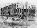
| Description: | A reproduction of an early print of a long, two-story wooden building with a front porch identified as the Tyler House. A man drives a horse-drawn wagon in... |

| Date: | 1926 |
|---|---|
| Description: | View from across street of the ornate terra cotta facade of the Al. Ringling Theatre, with advertisements for Rex (The Wonder Horse) in the silent movie, "... |

| Date: | 1926 |
|---|---|
| Description: | Exterior view from road of the Liberty Norwegian Lutheran Congregation. |

| Date: | 1926 |
|---|---|
| Description: | This 1926 map of Sawyer County, Wisconsin, the township and range system, towns, sections, cities and villages, railroads, highways and roads, and lakes an... |
| Date: | 1926 |
|---|---|
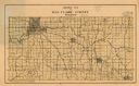
| Description: | Map of Eau Claire County, Wisconsin Shows highways, railroads, hydrography, and townships. |

| Date: | 1926 |
|---|---|
| Description: | This map shows streets, railroads, parks, and cemeteries. The top right includes an advertisement for Bartles-Maguire Oil Co. Wards are colored in red, yel... |

| Date: | 1926 |
|---|---|
| Description: | This brochure was intended for tourists and shows resorts, lakes and railroads in northwestern Wisconsin and part of Michigan’s upper peninsula. Also inclu... |

| Date: | 1926 |
|---|---|
| Description: | This blueprint manuscript map shows buildings, railroads, and United States property. Water depths shown by soundings, tints, and isolines. |

| Date: | 1926 |
|---|---|
| Description: | This blueprint map shows the Sheboygan River, buildings, and roads in the vicinity of the harbor. The map has explanations including "dredging required to ... |

| Date: | 1926 |
|---|---|
| Description: | This map includes a legend in the lower right corner of building heights. Districts marked "A" are 35 foot, districts marked "B" are 45 foot, districts mar... |

| Date: | 1926 |
|---|---|
| Description: | This map includes a legend in the lower right corner of land use. Districts are shown in five different shading for: "A" residential, "B" are residential, ... |
| Date: | 1926 |
|---|---|
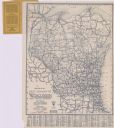
| Description: | This map shows paved roads, highways, road distances, cities, lakes, rivers, and county boundaries. Included are portions of Minnesota, Iowa, and Michigan.... |
| Date: | 1926 |
|---|---|
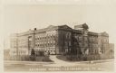
| Description: | Photographic postcard view of the Normal School, an original building for the University of Wisconsin-La Crosse located at 1724 State Street. Caption reads... |
If you didn't find the material you searched for, our Library Reference Staff can help.
Call our reference desk at 608-264-6535 or email us at:
