 Filter: Categories of Wisconsin Historical Images
Filter: FULL_DATE of 1926
Filter: Subject of transportation
Filter: Type of Photograph
Filter: Categories of Wisconsin Historical Images
Filter: FULL_DATE of 1926
Filter: Subject of transportation
Filter: Type of Photograph
| Date: | 1926 |
|---|---|
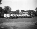
| Description: | A line of Kennedy Dairy horse-drawn wagons with drivers posing beside them. For Quaker Oats Farm. |
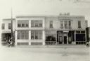
| Date: | 1926 |
|---|---|
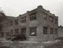
| Description: | Exterior view of the French Battery and Carbon Company office building. |
| Date: | 1926 |
|---|---|
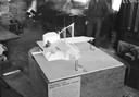
| Description: | Architectural model of a village type roadside service station designed by Frank Lloyd Wright. Men are standing behind the model, and there is a fire in th... |
| Date: | 1926 |
|---|---|
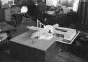
| Description: | Architectural model of a village-type gasoline station designed by Frank Lloyd Wright on display at Taliesin. Taliesin is located in the vicinity of Spring... |
| Date: | 1926 |
|---|---|
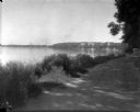
| Description: | Lake Mendota, including Fraternity Row and east side shoreline, taken from the lake path on University Bay Drive. |

| Date: | 1926 |
|---|---|
| Description: | View towards an open-air theatre from University of Wisconsin Observatory Drive. |
| Date: | 1926 |
|---|---|
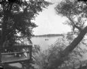
| Description: | View of Picnic Point across University Bay on Lake Mendota. There is a willow tree in the foreground. People are in a canoe out on the water. |
| Date: | 1926 |
|---|---|
| Description: | View across W. Johnson Street towards the back side of the Orpheum Theater under construction at 216 State Street. The house beside the theater on the left... |
| Date: | 1926 |
|---|---|
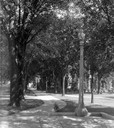
| Description: | View from the top of Bascom Hill on the University of Wisconsin-Madison campus of the tree-lined path and lampposts. South Hall is on the right. |
| Date: | 1926 |
|---|---|
| Description: | View of Adams, Tripp and Van Hise Halls. All are residence halls on the University of Wisconsin campus with Picnic Point and Lake Mendota in the backgroun... |

| Date: | 1926 |
|---|---|
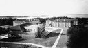
| Description: | Originally titled 'Recent Aeroplane View of University Campus', the view of the Wisconsin Historical Society, the Red Gym, Science Hall and Bascom Hall wit... |
| Date: | 1926 |
|---|---|
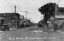
| Description: | Main Street, with two competing curb-side gas stations across the street from each other. Cars are parked along both sides of the muddy street. Such curb-... |
| Date: | 1926 |
|---|---|
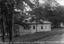
| Description: | Caption reads: "Chapel at Willerup Camp — Lake Ripley — Cambrdige. Wis." The camp was named for the Danish immigrant minister, Christian B. Willerup, who e... |
| Date: | 1926 |
|---|---|
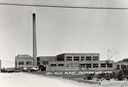
| Description: | Dry milk plant with a very tall smokestack. Some trucks are parked on the left. |
| Date: | 1926 |
|---|---|
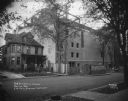
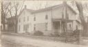
| Description: | View of a tavern set in a neighborhood, and surrounded by houses and trees. |
| Date: | 1926 |
|---|---|
| Description: | Exterior view of the Neighborhood House, Madison's only settlement house. |
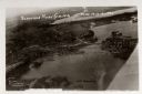
| Date: | 1926 |
|---|---|
| Description: | Aerial view with Wisconsin River. Caption reads: "Schofield Home Coming June 16-17-18-1927". The wing of an airplane is in the right foreground. |
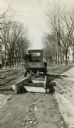
| Date: | 1926 |
|---|---|
| Description: | Road crew pulling a wooden, apparently homemade, road grader. It is a variation on the "Wisconsin Road Planer," a design perfected by the Highway Commissi... |
| Date: | 1926 |
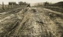
|---|---|
| Description: | Car on a dirt highway west of Hustler. The highway is U.S. 12 and 16. |
| Date: | 1926 |
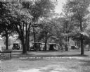
|---|---|
| Description: | The tourist camp that the citizens of Chippewa Falls provided free for motorists passing through their community. |
If you didn't find the material you searched for, our Library Reference Staff can help.
Call our reference desk at 608-264-6535 or email us at: