 Filter: Categories of Wisconsin Historical Images
Filter: FULL_DATE of 1926
Filter: Subject of rivers
Filter: Categories of Wisconsin Historical Images
Filter: FULL_DATE of 1926
Filter: Subject of rivers

| Date: | 1926 |
|---|---|
| Description: | This hand-colored blueprint map shows landowners in part of T15N, R5E in Juneau County. North is oriented to the right. |
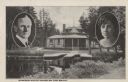
| Date: | 1926 |
|---|---|
| Description: | Black and white postcard view of Cedar Island Lodge, located on the Brule River, owned by Henry Clay Pierce, businessman and financier. It was dubbed the S... |

| Date: | 1926 |
|---|---|
| Description: | A topographic map of Green County, showing by contours and spot heights the topographic and natural features of the county. The contour intervals are 20 fe... |

| Date: | 1926 |
|---|---|
| Description: | A brochure with a map of Interstate Park on the Dalles of the Saint Croix River, showing locations of the north and south camp grounds, the fish hatcheries... |

| Date: | 1926 |
|---|---|
| Description: | Relief shown by hachures. Shows local streets, roads, railroads, businesses, Half Moon Lake, Chippewa River, and log reservoir. |

| Date: | 1926 |
|---|---|
| Description: | View from hill looking down at homes and businesses in town. A bridge goes over the Kickapoo River. The depot and railroad tracks and Main Street are behin... |

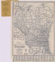
| Date: | 1926 |
|---|---|
| Description: | This map shows the state trunk highway system and county trunk highways. The lower left corner includes a legend of roadway types. Lake Michigan and Lake S... |

| Date: | 1926 |
|---|---|
| Description: | This blueprint map shows the Sheboygan River, buildings, and roads in the vicinity of the harbor. The map has explanations including "dredging required to ... |

| Date: | 1926 |
|---|---|
| Description: | This map includes a legend in the lower right corner of building heights. Districts marked "A" are 35 foot, districts marked "B" are 45 foot, districts mar... |

| Date: | 1926 |
|---|---|
| Description: | This map includes a legend in the lower right corner of land use. Districts are shown in five different shading for: "A" residential, "B" are residential, ... |

| Date: | 1926 |
|---|---|
| Description: | This map shows road surfacings, camp sites, state parks, proposed state parks, rivers, lakes, county boundaries, and cities. Includes portions of Minnesota... |
| Date: | 1926 |
|---|---|
| Description: | This map shows paved roads, highways, road distances, cities, lakes, rivers, and county boundaries. Included are portions of Minnesota, Iowa, and Michigan.... |
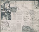
| Date: | 1926 |
|---|---|
| Description: | These maps are composites of selected exhibits and evidence submitted to the Supreme Court by the states of Wisconsin and Michigan between 1923 and 1926. T... |

| Date: | 1926 |
|---|---|
| Description: | View of the Northern Paper Mill on the banks of the Fox River. Caption reads: "Northern Paper Mills, Green Bay, Wis." |
If you didn't find the material you searched for, our Library Reference Staff can help.
Call our reference desk at 608-264-6535 or email us at:
