 Filter: Categories of Wisconsin Historical Images
Filter: FULL_DATE of 1926
Filter: Subject of recreation areas
Filter: Categories of Wisconsin Historical Images
Filter: FULL_DATE of 1926
Filter: Subject of recreation areas
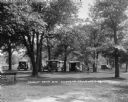
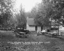
| Date: | 1926 |
|---|---|
| Description: | The tourist camp that the citizens of Chippewa Falls provided free for motorists passing through their community. |
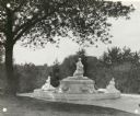
| Date: | 1926 |
|---|---|
| Description: | View of Memorial Fountain at Vilas Park. The lower two statues are of children and the center fountain is of a mother and child. |
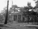
| Date: | 1926 |
|---|---|
| Description: | A gazebo dedicated to solders and sailors in Irvine Park. A flagpole and benches are in front of the gazebo. |
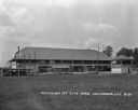
| Date: | 1926 |
|---|---|
| Description: | Pavilion, judge's stand, and other small structures at Firemans City Park. |
| Date: | 1926 |
|---|---|
| Description: | A group of women and children sit at a picnic table at the Black Bridge Boat Livery off Highway 12. Behind them is a building with a screened porch facing ... |

| Date: | 1926 |
|---|---|
| Description: | A brochure with a map of Interstate Park on the Dalles of the Saint Croix River, showing locations of the north and south camp grounds, the fish hatcheries... |
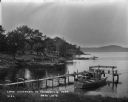
| Date: | 1926 |
|---|---|
| Description: | Lake Wisconsin at Summerville Park. Boathouses, docks and fishing boats are along the shoreline. |
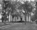
| Date: | 1926 |
|---|---|
| Description: | Public school and grounds. There is a slide on the lawn on the right. A dirt path leads up to the stairs to the entrance. |
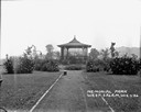
| Date: | 1926 |
|---|---|
| Description: | View down path of Memorial Park. A pavilion in the center is surrounded by bushes and plants. |

| Date: | 1926 |
|---|---|
| Description: | This map is oriented with the north to the upper right and shows a plat of the area, numbered blocks, lots, and wards, land ownership by name, local street... |

| Date: | 1926 |
|---|---|
| Description: | This map shows streets, railroads, parks, and cemeteries. The top right includes an advertisement for Bartles-Maguire Oil Co. Wards are colored in red, yel... |

| Date: | 1926 |
|---|---|
| Description: | This map includes a legend in the lower right corner of building heights. Districts marked "A" are 35 foot, districts marked "B" are 45 foot, districts mar... |

| Date: | 1926 |
|---|---|
| Description: | This map includes a legend in the lower right corner of land use. Districts are shown in five different shading for: "A" residential, "B" are residential, ... |
If you didn't find the material you searched for, our Library Reference Staff can help.
Call our reference desk at 608-264-6535 or email us at: