 Filter: Categories of Wisconsin Historical Images
Filter: FULL_DATE of 1926
Filter: Subject of human settlements
Filter: Categories of Wisconsin Historical Images
Filter: FULL_DATE of 1926
Filter: Subject of human settlements

| Date: | 1926 |
|---|---|
| Description: | View down Main Street. Shops and parked cars line the street. On the near left, there is a billboard for Granger rough cut tobacco, and there is a barbers... |

| Date: | 1926 |
|---|---|
| Description: | Exterior of Saint Paul's Catholic Church. Tree leaves cover the top-right corner of the image. There is a street sign for "Fourth St." on a power line pole... |

| Date: | 1926 |
|---|---|
| Description: | View across street of the exterior of the Bank of New Glarus on the corner of the street. |

| Date: | 1926 |
|---|---|
| Description: | A topographic map of Green County, showing by contours and spot heights the topographic and natural features of the county. The contour intervals are 20 fe... |
| Date: | 1926 |
|---|---|
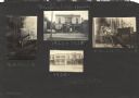
| Description: | First page of an album kept by Neighborhood House, with individual images of head resident Gay Braxton, second resident Mary Lee Griggs, and two exterior v... |

| Date: | 1926 |
|---|---|
| Description: | A map of Lincoln County, Wisconsin that shows the township and range grid, towns, cities and villages, lakes and streams, residences, churches, school hous... |

| Date: | 1926 |
|---|---|
| Description: | This Wisconsin Conservation Commission map from the 1920s shows roads, railroads, campsites, lookout towers, and privately owned lands in Northern Forest S... |
| Date: | 1926 |
|---|---|
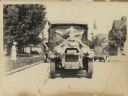
| Description: | Front view of a truck decorated for a parade. Manufactured by the White Motor Company, used as a Bamby Bread delivery truck. |

| Date: | 1926 |
|---|---|
| Description: | This 1926 map of Sawyer County, Wisconsin, the township and range system, towns, sections, cities and villages, railroads, highways and roads, and lakes an... |

| Date: | 1926 |
|---|---|
| Description: | This 1926 map depicts resorts and camps, lakes and streams, railroads, and roads in portions of Vilas, Iron, Oneida, Price, and Lincoln counties in Wiscons... |
| Date: | 1926 |
|---|---|
| Description: | Map of Eau Claire County, Wisconsin Shows highways, railroads, hydrography, and townships. |
| Date: | 1926 |
|---|---|
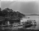
| Description: | Lake Wisconsin at Summerville Park. Boathouses, docks and fishing boats are along the shoreline. |

| Date: | 1926 |
|---|---|
| Description: | Relief shown by hachures. Shows local streets, roads, railroads, businesses, Half Moon Lake, Chippewa River, and log reservoir. |
| Date: | 1926 |
|---|---|
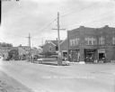
| Description: | View across street of the Farmers Merchants Bank on a corner. On the right are parked cars along the curb in front of "Onsgard Bros." which has a Red Crown... |
| Date: | 1926 |
|---|---|
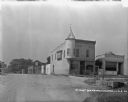
| Description: | View across street towards the Honeysett Oil Co. Filling Station, which is a two-story brick building. A woman and two children are on the stoop of a house... |
| Date: | 1926 |
|---|---|
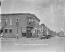
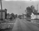
| Description: | View down street towards business district. At the t-intersection is a large commercial building with a turret on the second floor. Next door on the right ... |
| Date: | 1926 |
|---|---|
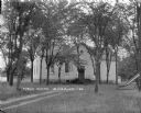
| Description: | Public school and grounds. There is a slide on the lawn on the right. A dirt path leads up to the stairs to the entrance. |
| Date: | 1926 |
|---|---|
| Description: | View of Main Street with puddles along the side of the street. Trucks and automobiles are traveling down the street, and are parked on the left. A restaura... |

| Date: | 1926 |
|---|---|
| Description: | View from road of a service station on the left with gas pumps. Next door is a meat market, a restaurant and a bank. A man is standing in front of the serv... |
If you didn't find the material you searched for, our Library Reference Staff can help.
Call our reference desk at 608-264-6535 or email us at:
