 Filter: Categories of Wisconsin Historical Images
Filter: FULL_DATE of 1926
Filter: Subject of fishing
Filter: Categories of Wisconsin Historical Images
Filter: FULL_DATE of 1926
Filter: Subject of fishing
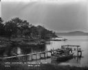
| Date: | 1926 |
|---|---|
| Description: | View from shoreline of boat landing. A boy rows a boat nearby, and another boy fishes from a boat resting on the shoreline. |

| Date: | 1926 |
|---|---|
| Description: | A brochure with a map of Interstate Park on the Dalles of the Saint Croix River, showing locations of the north and south camp grounds, the fish hatcheries... |
| Date: | 1926 |
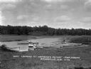
|---|---|
| Description: | Lake Wisconsin at Summerville Park. Boathouses, docks and fishing boats are along the shoreline. |

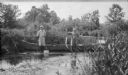
| Date: | 1926 |
|---|---|
| Description: | Men and boys fishing at Jordan Lake. One man is standing next to a boat pulled up at the shore and is holding up his catch of the day. There are cattails a... |

| Date: | 1926 |
|---|---|
| Description: | This brochure was intended for tourists and shows resorts, lakes and railroads in northwestern Wisconsin and part of Michigan’s upper peninsula. Also inclu... |
| Date: | 1926 |
|---|---|
| Description: | Herbert E. Brumder, left, posing and holding a fishing net in one hand, and the rope to a fishing bucket in the other hand, while standing in front of a mo... |
If you didn't find the material you searched for, our Library Reference Staff can help.
Call our reference desk at 608-264-6535 or email us at: