 Filter: Categories of Wisconsin Historical Images
Filter: FULL_DATE of 1926
Filter: Subject of express highways
Filter: Categories of Wisconsin Historical Images
Filter: FULL_DATE of 1926
Filter: Subject of express highways

| Date: | 1926 |
|---|---|
| Description: | A topographic map of Green County, showing by contours and spot heights the topographic and natural features of the county. The contour intervals are 20 fe... |

| Date: | 1926 |
|---|---|
| Description: | A map of Lincoln County, Wisconsin that shows the township and range grid, towns, cities and villages, lakes and streams, residences, churches, school hous... |

| Date: | 1926 |
|---|---|
| Description: | This 1926 map of Sawyer County, Wisconsin, the township and range system, towns, sections, cities and villages, railroads, highways and roads, and lakes an... |
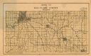
| Date: | 1926 |
|---|---|
| Description: | Map of Eau Claire County, Wisconsin Shows highways, railroads, hydrography, and townships. |

| Date: | 1926 |
|---|---|
| Description: | This map shows the state trunk highway system and county trunk highways. The lower left corner includes a legend of roadway types. Lake Michigan and Lake S... |
If you didn't find the material you searched for, our Library Reference Staff can help.
Call our reference desk at 608-264-6535 or email us at: