 Filter: Categories of Wisconsin Historical Images
Filter: FULL_DATE of 1926
Filter: Subject of cemeteries
Filter: Categories of Wisconsin Historical Images
Filter: FULL_DATE of 1926
Filter: Subject of cemeteries

| Date: | 1926 |
|---|---|
| Description: | This map shows streets, railroads, parks, and cemeteries. The top right includes an advertisement for Bartles-Maguire Oil Co. Wards are colored in red, yel... |

| Date: | 1926 |
|---|---|
| Description: | This map includes a legend in the lower right corner of building heights. Districts marked "A" are 35 foot, districts marked "B" are 45 foot, districts mar... |

| Date: | 1926 |
|---|---|
| Description: | This map includes a legend in the lower right corner of land use. Districts are shown in five different shading for: "A" residential, "B" are residential, ... |
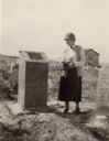
| Date: | 1926 |
|---|---|
| Description: | A woman holding flowers is standing between two graves, looking at the one on the left. Caption reads: "Wind River Indian Reservation (formerly the Shosho... |
If you didn't find the material you searched for, our Library Reference Staff can help.
Call our reference desk at 608-264-6535 or email us at: