 Filter: Categories of Wisconsin Historical Images
Filter: FULL_DATE of 1925
Filter: Year of 1900-1999
Filter: Subject of streams
Filter: Categories of Wisconsin Historical Images
Filter: FULL_DATE of 1925
Filter: Year of 1900-1999
Filter: Subject of streams
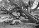
| Date: | 1925 |
|---|---|
| Description: | A flock of sheep graze under old willow trees alongside a stream. |
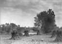
| Date: | 1925 |
|---|---|
| Description: | Corn shocks stand in a field with several pumpkins on the ground. There is a stream or river along the field, and in the background is a bridge over a dam... |

| Date: | 1925 |
|---|---|
| Description: | This 1925 map of the northern portion of Sawyer County, Wisconsin, shows the township and range system, sections, roads, railroads, and lakes and streams i... |

| Date: | 1925 |
|---|---|
| Description: | This 1925 map of Ashland County, Wisconsin, shows the township and range system, towns, sections, cities and villages, the Bad River Indian Reservation, ra... |

| Date: | 1925 |
|---|---|
| Description: | This 1925 map of Dane County, Wisconsin, issued by the Madison Association of Commerce shows the township and range grid, towns, sections, cities and villa... |
If you didn't find the material you searched for, our Library Reference Staff can help.
Call our reference desk at 608-264-6535 or email us at: