 Filter: Categories of Wisconsin Historical Images
Filter: FULL_DATE of 1925
Filter: Subject of michigan, lake
Filter: Categories of Wisconsin Historical Images
Filter: FULL_DATE of 1925
Filter: Subject of michigan, lake
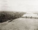
| Date: | 1925 |
|---|---|
| Description: | Aerial view of Green Bay, including the Jorgensen-Blesch Company building and two bridges. |

| Date: | 1925 |
|---|---|
| Description: | This map shows state trunk highways, county trunk highways, railroads, canoe trails, lakes, and free public camp sites. The map on the reverse also shows a... |
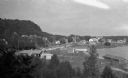
| Date: | 1925 |
|---|---|
| Description: | Elevated view of Fish Creek from the east; the bluff rises on the left, the harbor is on the right. The cottage in the foreground with pergola and lattice ... |
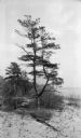
| Date: | 1925 |
|---|---|
| Description: | View looking north on the shore of Europe bay. A picturesque old pine stands near the site of the old pier. |
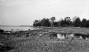
| Date: | 1925 |
|---|---|
| Description: | Rocky shoreline at Nelson Point, now in Peninsula State Park. |
| Date: | 1925 |
|---|---|
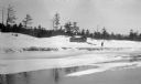
| Description: | View from water of a man with a long walking stick posing near a wooden boathouse on Europe Bay. There is ice on the water near the shore. |
| Date: | 1925 |
|---|---|
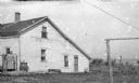
| Description: | A woman stands by the gate beside a wooden house, possibly at Newport. The house's downspout drains into a rain barrel. Lake Michigan is in the background... |
| Date: | 1925 |
|---|---|
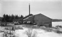
| Description: | Logs are stacked beside a sawmill in a winter landscape. The mill has a tall smokestack and stands near the shore. |
| Date: | 1925 |
|---|---|
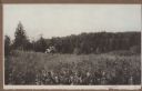
| Description: | Two young men pick berries in a field on a hill near Juddville. Chambers Island is seen on the horizon of the Green Bay. |

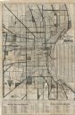
| Date: | 1925 |
|---|---|
| Description: | This map shows a plat of the city, local streets, railroads, public buildings, local businesses, and parts of the Manitowoc River and Lake Michigan. Relief... |

| Date: | 1925 |
|---|---|
| Description: | This map shows lakes, islands and bays. The Upper Peninsula of Michigan and Ontario are labeled. Three inset maps include the Upper end of St. Marys River ... |

| Date: | 1925 |
|---|---|
| Description: | This map shows the state trunk highway system and county trunk highways. The lower left corner includes a legend of roadway types. Lake Michigan and Lake S... |
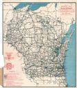
| Date: | 1925 |
|---|---|
| Description: | This map shows the state trunk highway system and county trunk highways. The lower left corner includes a legend of roadway types. Lake Michigan and Lake S... |
| Date: | 1925 |
|---|---|
| Description: | This map shows the routes of half-day and all-day trips from the Milwaukee area. The map highlights roads, land parcels, routes and destinations. Lake Mic... |

| Date: | 1925 |
|---|---|
| Description: | This map shows road surfacing, camp sites, rivers, lakes, county boundaries, and cities. Original caption reads, "Compliments Hotel Witter Tour Information... |
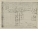
| Date: | 1925 |
|---|---|
| Description: | This series of 11 maps plus an index show the rivers as well as riverside buildings, landownership, and streets. |

| Date: | 1925 |
|---|---|
| Description: | The map shows the entire state with portions of Illinois, Iowa, Minnesota, and Michigan. The map shows concrete, gravel, all weather earth, clay, and sand ... |

| Date: | 1925 |
|---|---|
| Description: | Marion Briggs is standing and posing wearing a swimming suit and bathing cap for a full-length photograph. On the reverse of the photograph is written: "He... |
If you didn't find the material you searched for, our Library Reference Staff can help.
Call our reference desk at 608-264-6535 or email us at: