| Date: | 1925 |
|---|---|
| Description: | A map of the farm planned by Edwin Bottomley in 1844. |

| Date: | 1925 |
|---|---|
| Description: | Advertisement for C.L. Best tractors, promoting: "Quick Service from carefully selected vantage points also keeps Best Tractors on the job." An illustratio... |

| Date: | 1925 |
|---|---|
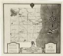
| Description: | This map shows trails, mounds, villages, corn fields, and contemporary civil townships; some villages and features include both Indian and English place na... |

| Date: | 1925 |
|---|---|
| Description: | The map shows the entire state with portions of Illinois, Iowa, Minnesota, and Michigan. The map shows concrete, gravel, all weather earth, clay, and sand ... |

| Date: | 1925 |
|---|---|
| Description: | Map of northern Africa with the border between Algeria and Tunisia drawn in red. Caption reads: "199A — (L61208) Map Series 2 The Eastern Barbary States." |

| Date: | 1925 |
|---|---|
| Description: | Equipment is set-up in a laboratory at Trout Lake. A map of Oneida County is on the far wall between two windows. |
If you didn't find the material you searched for, our Library Reference Staff can help.
Call our reference desk at 608-264-6535 or email us at: