 Filter: Categories of Wisconsin Historical Images
Filter: FULL_DATE of 1925
Filter: Subject of human settlements
Filter: Categories of Wisconsin Historical Images
Filter: FULL_DATE of 1925
Filter: Subject of human settlements

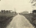
| Date: | 1925 |
|---|---|
| Description: | Elevated view of Mount Vernon from the a grassy hill. |
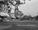
| Date: | 1925 |
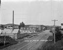
|---|---|
| Description: | View down a commercial street, with Engler's store located on the left. |

| Date: | 1925 |
|---|---|
| Description: | View from a pedestrian walkway looking towards the central business area. A concrete four-sided sign is in the center of intersection. |

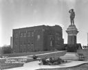
| Date: | 1925 |
|---|---|
| Description: | Exterior across lawn of the three-story New Glarus high school. The school building features a decommissioned Civil War cannon near the entrance. |

| Date: | 1925 |
|---|---|
| Description: | View down the road leading to the PET evaporated milk factory. A painted sign on the factory's exterior wall claims PET evaporated milk is "milk at its bes... |
| Date: | 1925 |
|---|---|
| Description: | Outside the Swingli House, near a memorial for the first New Glarus settlers. |

| Date: | 1925 |
|---|---|
| Description: | View down railroad tracks towards the New Glarus train depot. In the background is a water tower and a windmill. |

| Date: | 1925 |
|---|---|
| Description: | Page from an album kept by Neighborhood House, with images of infants and young children being cared for at the settlement house, including a group outside... |

| Date: | 1925 |
|---|---|
| Description: | This map of Price County, Wisconsin, from the early 20th century shows the township and range system, towns, sections, cities and villages, railroads, high... |

| Date: | 1925 |
|---|---|
| Description: | This map of Price County, Wisconsin, from the early 20th century shows the township and range system, towns, sections, cities and villages, railroads, high... |

| Date: | 1925 |
|---|---|
| Description: | This 1925 map of the northern portion of Sawyer County, Wisconsin, shows the township and range system, sections, roads, railroads, and lakes and streams i... |

| Date: | 1925 |
|---|---|
| Description: | This 1925 map of Ashland County, Wisconsin, shows the township and range system, towns, sections, cities and villages, the Bad River Indian Reservation, ra... |

| Date: | 1925 |
|---|---|
| Description: | This 1925 map of Dane County, Wisconsin, issued by the Madison Association of Commerce shows the township and range grid, towns, sections, cities and villa... |

| Date: | 1925 |
|---|---|
| Description: | Shows buildings, piers, winter and summer levels, and resort lands. Depths shown by isolines. Relief shown by contours. From the E.P. Sherry papers relatin... |
| Date: | 1925 |
|---|---|
| Description: | View down dirt road running through homes and trees in a neighborhood. A man stands in the road. Text at foot of photograph reads, "Toelle Ave. 138+12 Look... |
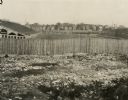
| Date: | 1925 |
|---|---|
| Description: | View of football field and bleachers from railroad embankment. In the foreground is rubble against a wooden fence. In the middle of the football field a nu... |

| Date: | 1925 |
|---|---|
| Description: | Map produced by the Paul E. Stark Company to advertising sales and services. Bottom of the map features sales records for 1919 to 1925 and a paragraph read... |

| Date: | 1925 |
|---|---|
| Description: | Map produced by the Paul E. Stark Company to advertising sales and services. Bottom of the map features sales records for 1919 to 1925 and a paragraph read... |
| Date: | 1925 |
|---|---|
| Description: | Elevated view of Main Street, with industrial and commercial buildings. Cars are parked at the curb towards the far end of the street, and fields and tree-... |
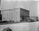
| Date: | 1925 |
|---|---|
| Description: | View across street of the Bettinger Store, with men standing on the sidewalk in front near a truck parked at the curb. Further down the street is a gas pum... |
If you didn't find the material you searched for, our Library Reference Staff can help.
Call our reference desk at 608-264-6535 or email us at: