 Filter: Categories of Wisconsin Historical Images
Filter: FULL_DATE of 1925
Filter: Subject of harbors
Filter: Categories of Wisconsin Historical Images
Filter: FULL_DATE of 1925
Filter: Subject of harbors
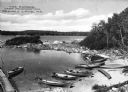
| Date: | 1925 |
|---|---|
| Description: | Elevated view of the harbor at Camp Kennington with boats pulled onto the shore of a small inlet, part of Lake Sebago. Caption reads: "The Harbor, Camp Ken... |
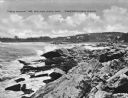
| Date: | 1925 |
|---|---|
| Description: | View along rocky coastline with crashing waves. Buildings are along the shoreline in the distance. Caption reads: "View from Ye Headland Inn. Trefethen, Ma... |
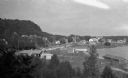
| Date: | 1925 |
|---|---|
| Description: | Elevated view of Fish Creek from the east; the bluff rises on the left, the harbor is on the right. The cottage in the foreground with pergola and lattice ... |

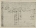
| Date: | 1925 |
|---|---|
| Description: | This map of Howard's Bay located at the Duluth Superior Harbor is a close view of Connors Point and shows a key to prevailing winds and water depth measure... |

| Date: | 1925 |
|---|---|
| Description: | This map shows a plat of the city, local streets, railroads, public buildings, local businesses, and parts of the Manitowoc River and Lake Michigan. Relief... |
| Date: | 1925 |
|---|---|
| Description: | This series of 11 maps plus an index show the rivers as well as riverside buildings, landownership, and streets. |
If you didn't find the material you searched for, our Library Reference Staff can help.
Call our reference desk at 608-264-6535 or email us at: