 Filter: Categories of Wisconsin Historical Images
Filter: FULL_DATE of 1925
Filter: Creator Name of Unknown
Filter: Type of Map or Atlas
Filter: Categories of Wisconsin Historical Images
Filter: FULL_DATE of 1925
Filter: Creator Name of Unknown
Filter: Type of Map or Atlas

| Date: | 1925 |
|---|---|
| Description: | A map of the farm planned by Edwin Bottomley in 1844. |

| Date: | 1925 |
|---|---|
| Description: | Sketch of the first floor plan of the house of Mr. Edwin Bottomley. |

| Date: | 1925 |
|---|---|
| Description: | This map shows the public schools and their school districts. The bottom of the map reads:" Old buildings and sites in red. New buildings and sites in blac... |
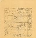
| Date: | 1925 |
|---|---|
| Description: | This map shows township sections, roads, railroads, and lakes. The map also features extensive manuscript annotations noting landownership in pencil. Stamp... |
If you didn't find the material you searched for, our Library Reference Staff can help.
Call our reference desk at 608-264-6535 or email us at: