Filter: Categories of Wisconsin Historical Images
Filter: FULL_DATE of 1924
Filter: Subject of rivers
Filter: Categories of Wisconsin Historical Images
Filter: FULL_DATE of 1924
Filter: Subject of rivers
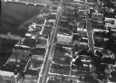
| Date: | 1924 |
|---|---|
| Description: | Aerial view of Green Bay's commercial district, bridges, and water. |
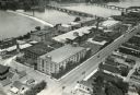
| Date: | 1924 |
|---|---|
| Description: | Aerial view of the International Harvester Rock Falls Works (factory). |
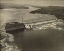
| Date: | 1924 |
|---|---|
| Description: | Aerial view of the Prairie du Sac hydroelectric plant and the surrounding landscape of the Wisconsin River. |
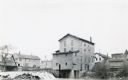
| Date: | 1924 |
|---|---|
| Description: | The dam and four-story wooden mill on the Baraboo River. A bridge crosses the river on the left. There are houses and commercial buildings in the backgrou... |
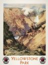
| Date: | 1924 |
|---|---|
| Description: | An original lithograph promoting the Grand Canyon of Yellowstone Park, and to get there by way of the Northern Pacific Railway. The poster depicts a dramat... |
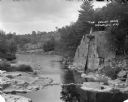
| Date: | 1924 |
|---|---|
| Description: | Elevated view of The Dells. A group of people are standing on a rock formation on the right overlooking the river. On the left is a rocky shoreline, and in... |
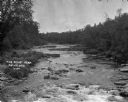
| Date: | 1924 |
|---|---|
| Description: | Elevated view looking upriver at The Dells. Trees and plants are along the shoreline. |
| Date: | 1924 |
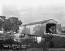
|---|---|
| Description: | View from shoreline of a covered bridge over a river. |
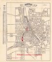
| Date: | 1924 |
|---|---|
| Description: | This map of Janesville was distrusted by the Fifield Lumber Company and features labeled streets, the Rock River, and Fifield Lumber Company buildings in r... |

| Date: | 1924 |
|---|---|
| Description: | This map shows streets, selected buildings, railroads, railway yards, schools, parks, schools, cemeteries, bays, the Milwaukee River, and Lake Michigan. De... |
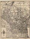
| Date: | 1924 |
|---|---|
| Description: | This map shows roads, cities, rivers,lakes, road surfacings and camp sites. Included are portions of Minnesota, Iowa, Illinois, and Michigan. Includes a le... |

| Date: | 1924 |
|---|---|
| Description: | A map of the Madison Township, T7N R9E including Lake Mendota showing the location of Ho Chunk encampments and effigy mounds. |
If you didn't find the material you searched for, our Library Reference Staff can help.
Call our reference desk at 608-264-6535 or email us at: