| Date: | 1924 |
|---|---|
| Description: | Plat map showing a portion of Liberty Grove, T32-33N R29E. The land is bordered on the south by Rowley's Bay, on the east by Lake Michigan and Europe Bay, ... |

| Date: | 1924 |
|---|---|
| Description: | This map is pen, pencil, and watercolor on paper and shows land ownership by name, local streets, railroads, and part of Chequamegon Bay. The map includes ... |

| Date: | 1924 |
|---|---|
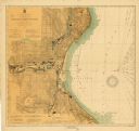
| Description: | This map shows streets, selected buildings, railroads, railway yards, schools, parks, schools, cemeteries, bays, the Milwaukee River, and Lake Michigan. De... |

| Date: | 1924 |
|---|---|
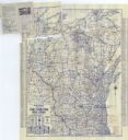
| Description: | This map shows automobile routes across the state and into parts of Minnesota, Iowa, Illinois, and Michigan. Cities, Lake Michigan, Lake Superior, Green Ba... |
If you didn't find the material you searched for, our Library Reference Staff can help.
Call our reference desk at 608-264-6535 or email us at: