 Filter: Categories of Wisconsin Historical Images
Filter: FULL_DATE of 1923
Filter: Subject of neighborhoods
Filter: Categories of Wisconsin Historical Images
Filter: FULL_DATE of 1923
Filter: Subject of neighborhoods
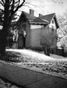
| Date: | 1923 |
|---|---|
| Description: | The Jarvis-Ward-Atwood octagon house, 121 West Wilson Street, built for Mr. Jarvis from red brick made at a kiln, owned by W.A.P. Morris, at the turn of La... |
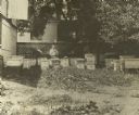
| Date: | 1923 |
|---|---|
| Description: | Beekeeper H.F. Wilson sitting among his hives in a backyard apiary. To his left, a hive smoker is resting on a hive letting off smoke. There are a least 25... |

| Date: | 1923 |
|---|---|
| Description: | Map showing the parcel of land on the shore of Lake Monona acquired by the City of Madison for a park (today known as Olbrich Park). |

| Date: | 1923 |
|---|---|
| Description: | This manuscript blueprint map shows land parcels regarding the development of the Shorewood community, located on the city side of Lake Mendota. Original c... |
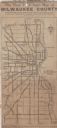
| Date: | 1923 |
|---|---|
| Description: | This map shows state, county, and city roadways as well as neighborhoods. Lake Michigan is on the far right. |
If you didn't find the material you searched for, our Library Reference Staff can help.
Call our reference desk at 608-264-6535 or email us at: