 Filter: Categories of Wisconsin Historical Images
Filter: FULL_DATE of 1923
Filter: Subject of michigan, lake
Filter: Categories of Wisconsin Historical Images
Filter: FULL_DATE of 1923
Filter: Subject of michigan, lake

| Date: | 1923 |
|---|---|
| Description: | This early road map shows the system of roads in Wisconsin, northern Illinois, northeastern Iowa, southeastern Minnesota, and the western portion of Michig... |
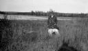
| Date: | 1923 |
|---|---|
| Description: | A well-dressed man poses holding a German short-haired pointer on a leash near the outlet of the Fish Creek into the harbor. |

| Date: | 1923 |
|---|---|
| Description: | A small cottage is barely visible through the trees on the rocky shore at Nelson Point, now part of Peninsula State Park. |

| Date: | 1923 |
|---|---|
| Description: | Sunlight glints off the water under a threatening sky. |

| Date: | 1923 |
|---|---|
| Description: | A man with a walking stick stands on the shore of frozen Europe Lake. The Hotz boat house and pier are in the background. |
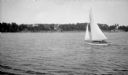
| Date: | 1923 |
|---|---|
| Description: | View across water of a small sailboat along the Door County shore. |

| Date: | 1923 |
|---|---|
| Description: | Two men, including Ferdinand L. (Fedy) Hotz, left, stand on the west shore of Spider Island off Door County. There is a small boat with an outboard motor ... |

| Date: | 1923 |
|---|---|
| Description: | This map shows counties, roads, Lake Superior, Lake Michigan, and portions of surrounding states. Included is an index to cities, villages and other places... |

| Date: | 1923 |
|---|---|
| Description: | This map includes an explanation that reads: "This chart shows the movement of barley on the Great Lakes, St. Lawrence River, and New York State Barge Cana... |

| Date: | 1923 |
|---|---|
| Description: | This map shows major cities surrounding the Great Lakes. Portions of Minnesota, Iowa, Illinois, Indiana, Ohio, Michigan, New York, Vermont, Massachusetts,C... |

| Date: | 1923 |
|---|---|
| Description: | This map includes an explanation that reads: "This chart shows the movement of corn on the Great Lakes, St. Lawrence River, and New York State Barge Canal ... |

| Date: | 1923 |
|---|---|
| Description: | This map includes an explanation that reads: "This chart shows the easterly movement of flaxseed on the Great Lakes, St. Lawrence River, and New York State... |

| Date: | 1923 |
|---|---|
| Description: | This map includes an explanation that reads: "This chart shows the movement of grain on the Great Lakes, St. Lawrence River, and New York State Barge Canal... |

| Date: | 1923 |
|---|---|
| Description: | This map shows the movement of iron ore in parts of Minnesota, Wisconsin, and the Upper Peninsula of Michigan, and includes parts of Lake Superior, Green B... |

| Date: | 1923 |
|---|---|
| Description: | This map shows the movement of iron ore along the Great Lakes. Portions of Minnesota, Iowa, Wisconsin, Illinois, Indiana, Ohio, Michigan, New York, Vermont... |

| Date: | 1923 |
|---|---|
| Description: | This map includes an explanation that reads: "This chart shows the movement of oats on the Great Lakes, St. Lawrence River, and New York State Barge Canal ... |

| Date: | 1923 |
|---|---|
| Description: | This map includes an explanation that reads: "This chart shows the movement of rye on the Great Lakes, St. Lawrence River, and New York State Barge Canal d... |

| Date: | 1923 |
|---|---|
| Description: | This map shows the movement of stone to cities along the Great Lakes. Portions of Minnesota, Iowa, Wisconsin, Illinois, Indiana, Ohio, Michigan, New York, ... |

| Date: | 1923 |
|---|---|
| Description: | This map shows steamship lines and cities along the Great Lakes. Portions of Minnesota, Iowa, Wisconsin, Illinois, Indiana, Ohio, Michigan, New York, Vermo... |

| Date: | 1923 |
|---|---|
| Description: | This map shows steamship lines and cities along the Great Lakes. Portions of Minnesota, Wisconsin, Illinois, Indiana, Ohio, Michigan, New York, Vermont, Ma... |
If you didn't find the material you searched for, our Library Reference Staff can help.
Call our reference desk at 608-264-6535 or email us at: