 Filter: Categories of Wisconsin Historical Images
Filter: FULL_DATE of 1923
Filter: Subject of lakes
Filter: Categories of Wisconsin Historical Images
Filter: FULL_DATE of 1923
Filter: Subject of lakes
| Date: | 1923 |
|---|---|
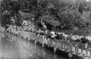
| Description: | Boys line up on pier for swimming race at Camp Wakanda. |
| Date: | 1923 |
|---|---|
| Description: | Aerial view of the University of Wisconsin campus shows from west to east the Agricultural Hall, Observatory Hall and the Wisconsin Historical Society with... |

| Date: | 1923 |
|---|---|
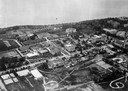
| Description: | Aerial view of the Wisconsin Historical Society, Science Hall, and Bascom Hall on Bascom Hill on the University of Wisconsin-Madison campus. Lake Mendota i... |

| Date: | 1923 |
|---|---|
| Description: | Vilas County. Published by Chicago, Milwaukee, and St. Paul Ry. |
| Date: | 1923 |
|---|---|
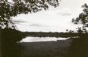
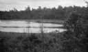
| Description: | View of Fountain Lake (officially known as Ennis Lake), John Muir's boyhood home near Montello. The area is now a 125-acre State Natural Area. Fountain Lak... |
| Date: | 1923 |
|---|---|
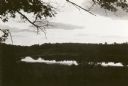
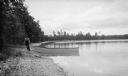
| Description: | View of Fountain Lake (officially known as Ennis Lake), John Muir's boyhood home near Montello. The area is now a 125-acre State Natural Area. Fountain Lak... |

| Date: | 1923 |
|---|---|
| Description: | This map shows trails, some in red, for automobiles. The right margin includes a key of markings as well as Minnesota and Wisconsin Highway signs. Communit... |

| Date: | 1923 |
|---|---|
| Description: | This early road map shows the system of roads in Wisconsin, northern Illinois, northeastern Iowa, southeastern Minnesota, and the western portion of Michig... |
| Date: | 1923 |
|---|---|
| Description: | View down hill of Fedy (Ferdinand Leonard) Hotz fishing while another man sits with him in a small boat with outboard motor. An oar rests in its lock. |
| Date: | 1923 |
|---|---|
| Description: | David Kincaid hauls a row boat onto shore with a rope. Kincaid was the caretaker of the Hotz Europe Lake estate. |
| Date: | 1923 |
|---|---|
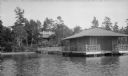
| Description: | View from the water of the Hotz family cottage, boathouse, and rustic pier on Europe Lake. |
| Date: | 1923 |
|---|---|
| Description: | The Hotz boathouse and pier are reflected in the still waters of Europe Lake. |

| Date: | 1923 |
|---|---|
| Description: | A hand-colored map of Marinette County, Wisconsin that shows, townships, towns and plot sections, lakes and streams, cities and villages, and rail lines an... |

| Date: | 1923 |
|---|---|
| Description: | This map from the Wisconsin Lakes and Parks Association shows the area of a proposed state park, much of which is now part of the Flambeau River State Fore... |

| Date: | 1923 |
|---|---|
| Description: | This topographical map of Devil's Lake State Park, Sauk County, Wisconsin, is based on 1922-1923 surveys of the area by the University of Wisconsin Summer ... |
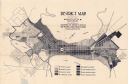
| Date: | 1923 |
|---|---|
| Description: | This map shows local streets, parks, Lake Wingra, and parts of Lake Mendota and Lake Monona. The map includes a legend showing residential, commercial, lig... |

| Date: | 1923 |
|---|---|
| Description: | Map showing the parcel of land on the shore of Lake Monona acquired by the City of Madison for a park (today known as Olbrich Park). |

| Date: | 1923 |
|---|---|
| Description: | This map shows counties, roads, Lake Superior, Lake Michigan, and portions of surrounding states. Included is an index to cities, villages and other places... |

| Date: | 1923 |
|---|---|
| Description: | This map includes an explanation that reads: "This chart shows the movement of barley on the Great Lakes, St. Lawrence River, and New York State Barge Cana... |

| Date: | 1923 |
|---|---|
| Description: | This map shows major cities surrounding the Great Lakes. Portions of Minnesota, Iowa, Illinois, Indiana, Ohio, Michigan, New York, Vermont, Massachusetts,C... |
If you didn't find the material you searched for, our Library Reference Staff can help.
Call our reference desk at 608-264-6535 or email us at: