 Filter: Categories of Wisconsin Historical Images
Filter: FULL_DATE of 1923
Filter: Subject of human settlements
Filter: Categories of Wisconsin Historical Images
Filter: FULL_DATE of 1923
Filter: Subject of human settlements

| Date: | 1923 |
|---|---|
| Description: | The Schoelkopf advertising truck parked on the street near the store at 210-216 E. Washington Avenue. The truck advertises a number of products: Rockway Sp... |

| Date: | 1923 |
|---|---|
| Description: | Elevated view looking down at the Automobile Repair Shop with a Good Year Tire sign in the window. Next door on the left is the J.I. McFarland Oldsmobile-C... |

| Date: | 1923 |
|---|---|
| Description: | Map showing the parcel of land on the shore of Lake Monona acquired by the City of Madison for a park (today known as Olbrich Park). |

| Date: | 1923 |
|---|---|
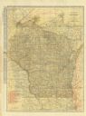
| Description: | This map shows counties, roads, Lake Superior, Lake Michigan, and portions of surrounding states. Included is an index to cities, villages and other places... |
| Date: | 1923 |
|---|---|
| Description: | The front of the map reads: "Wisconsin Railroads" and shows railroads, interurban lines, steamship lines sailing from Wisconsin ports, Duluth, Minn., and C... |

| Date: | 1923 |
|---|---|
| Description: | This blue line print map shows townships, landownership, roads, residences, churches, schools, town halls, saw mills, and cheese factories. Includes red ma... |

| Date: | 1923 |
|---|---|
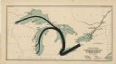
| Description: | This map includes an explanation that reads: "This chart shows the movement of barley on the Great Lakes, St. Lawrence River, and New York State Barge Cana... |

| Date: | 1923 |
|---|---|
| Description: | This map shows the movement from coalfields in Ohio, Pennsylvania, West Virginia, Kentucky, and part of Virginia to Lake Erie. Quantities of coal are label... |

| Date: | 1923 |
|---|---|
| Description: | This map includes an explanation that reads: "This chart shows the movement of grain on the Great Lakes, St. Lawrence River, and New York State Barge Canal... |

| Date: | 1923 |
|---|---|
| Description: | This map shows the movement of iron ore in areas of Ohio, Pennsylvania, New York, New Jersey, Lake Erie, Lake Ontario, and parts of Ontario, Maryland, and ... |

| Date: | 1923 |
|---|---|
| Description: | This map shows the movement of iron ore in parts of Minnesota, Wisconsin, and the Upper Peninsula of Michigan, and includes parts of Lake Superior, Green B... |

| Date: | 1923 |
|---|---|
| Description: | This map shows the movement of iron ore along the Great Lakes. Portions of Minnesota, Iowa, Wisconsin, Illinois, Indiana, Ohio, Michigan, New York, Vermont... |

| Date: | 1923 |
|---|---|
| Description: | This map includes an explanation that reads: "This chart shows the movement of oats on the Great Lakes, St. Lawrence River, and New York State Barge Canal ... |

| Date: | 1923 |
|---|---|
| Description: | This map includes an explanation that reads: "This chart shows the movement of rye on the Great Lakes, St. Lawrence River, and New York State Barge Canal d... |

| Date: | 1923 |
|---|---|
| Description: | This map shows portions of Minnesota, Iowa, Wisconsin, Illinois, Indiana, Ohio, Michigan, New York, Vermont, Massachusetts, Connecticut, Ontario, and Quebe... |
| Date: | 1923 |
|---|---|
| Description: | This map shows the movement of anthracite coal throughout Minnesota, Wisconsin, Ontario, Quebec, Michigan, Illinois, Indiana, and New York. Iowa, Vermont,... |

| Date: | 1923 |
|---|---|
| Description: | Pamphlet advertising classes for "foreigners" to learn English at the Neighborhood House. The Neighborhood House is pictured on the pamphlet with a U.S. fl... |

| Date: | 1923 |
|---|---|
| Description: | This map includes an explanation that reads: "This chart shows the movement of wheat on the Great Lakes, St. Lawrence River, and New York State Barge Canal... |

| Date: | 1923 |
|---|---|
| Description: | This manuscript blueprint map shows land parcels regarding the development of the Shorewood community, located on the city side of Lake Mendota. Original c... |

| Date: | 1923 |
|---|---|
| Description: | View of a street in downtown Stevens Point. Model T's are parked along the curbs. Children are standing near the cars on both sides of the street. |
If you didn't find the material you searched for, our Library Reference Staff can help.
Call our reference desk at 608-264-6535 or email us at: