 Filter: Categories of Wisconsin Historical Images
Filter: FULL_DATE of 1923
Filter: County of Dane
Filter: Type of Map or Atlas
Filter: Categories of Wisconsin Historical Images
Filter: FULL_DATE of 1923
Filter: County of Dane
Filter: Type of Map or Atlas
| Date: | 1923 |
|---|---|
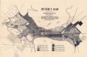
| Description: | This map shows local streets, parks, Lake Wingra, and parts of Lake Mendota and Lake Monona. The map includes a legend showing residential, commercial, lig... |

| Date: | 1923 |
|---|---|
| Description: | Map showing the parcel of land on the shore of Lake Monona acquired by the City of Madison for a park (today known as Olbrich Park). |

| Date: | 1923 |
|---|---|
| Description: | This manuscript blueprint map shows land parcels regarding the development of the Shorewood community, located on the city side of Lake Mendota. Original c... |
If you didn't find the material you searched for, our Library Reference Staff can help.
Call our reference desk at 608-264-6535 or email us at: