Filter: Categories of Wisconsin Historical Images
Filter: FULL_DATE of 1923
Filter: Type of Map or Atlas
Filter: Categories of Wisconsin Historical Images
Filter: FULL_DATE of 1923
Filter: Type of Map or Atlas

| Date: | 1923 |
|---|---|
| Description: | This map shows the movement of iron ore along the Great Lakes. Portions of Minnesota, Iowa, Wisconsin, Illinois, Indiana, Ohio, Michigan, New York, Vermont... |

| Date: | 1923 |
|---|---|
| Description: | This map includes an explanation that reads: "This chart shows the movement of oats on the Great Lakes, St. Lawrence River, and New York State Barge Canal ... |

| Date: | 1923 |
|---|---|
| Description: | This map includes an explanation that reads: "This chart shows the movement of rye on the Great Lakes, St. Lawrence River, and New York State Barge Canal d... |

| Date: | 1923 |
|---|---|
| Description: | This map shows the movement of stone to cities along the Great Lakes. Portions of Minnesota, Iowa, Wisconsin, Illinois, Indiana, Ohio, Michigan, New York, ... |

| Date: | 1923 |
|---|---|
| Description: | This map shows steamship lines and cities along the Great Lakes. Portions of Minnesota, Iowa, Wisconsin, Illinois, Indiana, Ohio, Michigan, New York, Vermo... |

| Date: | 1923 |
|---|---|
| Description: | This map shows steamship lines and cities along the Great Lakes. Portions of Minnesota, Wisconsin, Illinois, Indiana, Ohio, Michigan, New York, Vermont, Ma... |

| Date: | 1923 |
|---|---|
| Description: | This map shows portions of Minnesota, Iowa, Wisconsin, Illinois, Indiana, Ohio, Michigan, New York, Vermont, Massachusetts, Connecticut, Ontario, and Quebe... |

| Date: | 1923 |
|---|---|
| Description: | This map shows portions of Minnesota, Iowa, Wisconsin, Illinois, Indiana, Ohio, Michigan, New York, Vermont, Massachusetts, Connecticut, Ontario, and Quebe... |
| Date: | 1923 |
|---|---|
| Description: | This map shows the movement of anthracite coal throughout Minnesota, Wisconsin, Ontario, Quebec, Michigan, Illinois, Indiana, and New York. Iowa, Vermont,... |

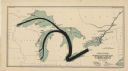
| Date: | 1923 |
|---|---|
| Description: | This map includes an explanation that reads: "This chart shows the movement of wheat on the Great Lakes, St. Lawrence River, and New York State Barge Canal... |

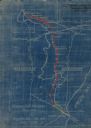
| Date: | 1923 |
|---|---|
| Description: | This manuscript blueprint map shows land parcels regarding the development of the Shorewood community, located on the city side of Lake Mendota. Original c... |
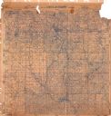
| Date: | 1923 |
|---|---|
| Description: | This map shows the county boundaries, with each dot representing 50 silos. |
| Date: | 1923 |
|---|---|
| Description: | This map shows road surfacing, cities, rivers, towns, roads, highways, and camp sites. Included are portions of Minnesota, Iowa, Illinois, and Michigan. La... |
| Date: | 1923 |
|---|---|
| Description: | This blueprint map shows Wisconsin and Michigan-owned railroad and trackage rights from Iron Mountain to Menominee, Michigan, as well as other railroads. W... |
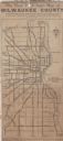
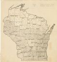
| Date: | 1923 |
|---|---|
| Description: | This map shows state, county, and city roadways as well as neighborhoods. Lake Michigan is on the far right. |
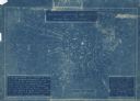
| Date: | 1923 |
|---|---|
| Description: | Blueprint U.S. map showing locations from which reports were received indicating reception of a basketball game broadcast by WHA radio out of Madison. |

| Date: | 1923 |
|---|---|
| Description: | Color map of the "Interborough Rapid Transit System of Greater New York". |

| Date: | 1923 |
|---|---|
| Description: | The back side of the map of the "Interborough Rapid Transit System of Greater New York". |
If you didn't find the material you searched for, our Library Reference Staff can help.
Call our reference desk at 608-264-6535 or email us at: