 Filter: Categories of Wisconsin Historical Images
Filter: FULL_DATE of 1922
Filter: Subject of transportation
Filter: Categories of Wisconsin Historical Images
Filter: FULL_DATE of 1922
Filter: Subject of transportation

| Date: | 1922 |
|---|---|
| Description: | View across street of Saint Mary's Church and School. |
| Date: | 1922 |
|---|---|
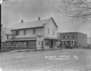
| Description: | View down a commercial street lined with shops and parked cars. On the left is a storefront with signs for "Garage" and "Red Crown Gasoline" above the door... |
| Date: | 1922 |
|---|---|
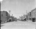
| Description: | View down the curved unpaved street. Two men and a dog stand under the awning of a shop on the left. Another group of men are posed near a car parked outsi... |
| Date: | 1922 |
|---|---|
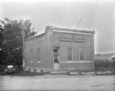
| Description: | Exterior of the Bank of Mindoro. A car is parked on the lawn beside the bank. On the back of the car is an advertisement for the Interstate Fair in La Cros... |

| Date: | 1922 |
|---|---|
| Description: | View from hill of cherry trees in bloom in the Gibraltar Orchard on Sturgeon Bay Road (Highway 42.) |

| Date: | 1922 |
|---|---|
| Description: | The Hotz Gibraltar Orchard cherry camp house with a low dormer in front; all windows and the porch are shuttered. There is a car parked in front of a log c... |

| Date: | 1922 |
|---|---|
| Description: | View down dirt road towards two automobiles, next to each other and going in different directions. Another automobile is parked in the background. On the r... |

| Date: | 1922 |
|---|---|
| Description: | View down dirt road towards a man, seen from behind, sitting on a plow pulled by a team of two horses, near an automobile facing the camera. Next to the au... |

| Date: | 1922 |
|---|---|
| Description: | A map of Iron County, Wisconsin, shows sections and the towns of Upson, Hurley, Hamilton, Saxon, and Mercer, lakes and streams, villages, railroads, roads ... |

| Date: | 1922 |
|---|---|
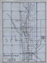
| Description: | A road map of Milwaukee County, Wisconsin that shows the township and range system, towns, communities, completed roads, a proposed system of roads, steam ... |

| Date: | 1922 |
|---|---|
| Description: | A bird's-eye map that shows the Milwaukee Parkway as contemplated by the Milwaukee County Planning Commission. The map identifies the roads and parks throu... |
| Date: | 1922 |
|---|---|
| Description: | A map of the Beaver Creek Valley in Monroe, Wisconsin along Beaver Creek and the La Crosse River, showing roads, railroads, and land ownership as well as p... |

| Date: | 1922 |
|---|---|
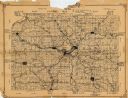
| Description: | This map from the early to mid-20th century shows the township and range system, towns, cities and villages, roads, railroads, schools, churches, cemeterie... |

| Date: | 1922 |
|---|---|
| Description: | This map from the early to mid-20th century shows the township and range system, towns, cities and villages, roads, railroads, schools, churches, and lakes... |

| Date: | 1922 |
|---|---|
| Description: | This map of Outagamie County, Wisconsin, from the first half of the 20th century, shows the township and range grid, towns, sections, cities and villages, ... |

| Date: | 1922 |
|---|---|
| Description: | This map of Pepin County, Wisconsin, from the first half of the 20th century shows the township and range grid, towns, villages, railroads, roads, schools,... |

| Date: | 1922 |
|---|---|
| Description: | This map of Pierce County, Wisconsin, from the first half of the 20th century, shows the township and range grid, towns, sections, villages, roads, railroa... |
| Date: | 1922 |
|---|---|
| Description: | This 1922 map of Dane County, Wisconsin, issued by the Madison Association of Commerce shows the township and range grid, towns, sections, cities and villa... |
| Date: | 1922 |
|---|---|
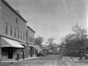
| Description: | View across street of commercial buildings, with a tree-lined hill in the far background. A group of men and women are standing on the porch of the brick b... |
| Date: | 1922 |
|---|---|
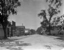
| Description: | View down middle of street, showing the central business district. A drug store, restaurant and hotel are on the left. A garage, bank, bathhouse, bowling a... |
If you didn't find the material you searched for, our Library Reference Staff can help.
Call our reference desk at 608-264-6535 or email us at: