 Filter: Categories of Wisconsin Historical Images
Filter: FULL_DATE of 1922
Filter: Subject of superior, lake
Filter: Categories of Wisconsin Historical Images
Filter: FULL_DATE of 1922
Filter: Subject of superior, lake

| Date: | 1922 |
|---|---|
| Description: | This map shows public libraries, state traveling libraries, and county traveling libraries. County boundaries are labeled. Lake Michigan is on the far righ... |
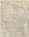
| Date: | 1922 |
|---|---|
| Description: | This map shows roads, highways, lakes, rivers, county boundaries, and cities. Selected businesses are highlighted in red. Includes an explanation of state ... |

| Date: | 1922 |
|---|---|
| Description: | This map shows in red the NorthWestern Railway Line routes running from Chicago, Illinois to northern Wisconsin. The map includes cities and towns, lakes, ... |
If you didn't find the material you searched for, our Library Reference Staff can help.
Call our reference desk at 608-264-6535 or email us at: