Filter: Categories of Wisconsin Historical Images
Filter: FULL_DATE of 1922
Filter: Subject of lakes
Filter: Categories of Wisconsin Historical Images
Filter: FULL_DATE of 1922
Filter: Subject of lakes

| Date: | 1922 |
|---|---|
| Description: | Aerial view of the Wisconsin State Capitol and Lake Monona. |
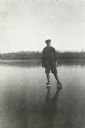
| Date: | 1922 |
|---|---|
| Description: | A young man, probably George Mattis, Jr., posing wearing ice skates on a frozen lake (possibly Knuteson Lake). |
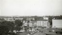
| Date: | 1922 |
|---|---|
| Description: | Elevated view looking west over Capitol Square from Pinckney Street and East Washington Avenue. Lake Mendota is in the distance. |
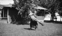
| Date: | 1922 |
|---|---|
| Description: | A woman playfully spins another woman (probably her daughter) in a yard in front of a house. There is a lake in the background. |

| Date: | 1922 |
|---|---|
| Description: | Mary Brandel sits at a picnic table with another woman. Mary is holding a ukulele and there is a cottage and lake in the background. |
| Date: | 1922 |
|---|---|
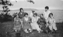
| Description: | Lakeside portrait of dressmaker Addie Noll of Milwaukee and her family. |
| Date: | 1922 |
|---|---|
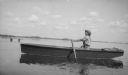
| Description: | Mary Brandel rows a boat on a lake (possibly Fox Lake). There is a wooden pier in the background. |

| Date: | 1922 |
|---|---|
| Description: | A young woman with long, loose hair sits in a chair in a yard. There is a cottage and lake in the background. She appears to have a mirror in her lap. |
| Date: | 1922 |
|---|---|
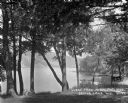
| Description: | View of Devil's Lake from the shore of the Kirkland Hotel, located at the southeast corner of the lake. There is building, perhaps a boathouse, on the shor... |
| Date: | 1922 |
|---|---|
| Description: | David Kincaid, caretaker of the Hotz Europe Lake estate, poses with a German shorthaired hunting dog. Europe Lake is in the background. |

| Date: | 1922 |
|---|---|
| Description: | A map of Iron County, Wisconsin, shows sections and the towns of Upson, Hurley, Hamilton, Saxon, and Mercer, lakes and streams, villages, railroads, roads ... |

| Date: | 1922 |
|---|---|
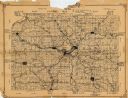
| Description: | This map from the early to mid-20th century shows the township and range system, towns, cities and villages, roads, railroads, schools, churches, cemeterie... |

| Date: | 1922 |
|---|---|
| Description: | This map from the early to mid-20th century shows the township and range system, towns, cities and villages, roads, railroads, schools, churches, and lakes... |

| Date: | 1922 |
|---|---|
| Description: | This map of Outagamie County, Wisconsin, from the first half of the 20th century, shows the township and range grid, towns, sections, cities and villages, ... |

| Date: | 1922 |
|---|---|
| Description: | This map of Pepin County, Wisconsin, from the first half of the 20th century shows the township and range grid, towns, villages, railroads, roads, schools,... |

| Date: | 1922 |
|---|---|
| Description: | This map of Pierce County, Wisconsin, from the first half of the 20th century, shows the township and range grid, towns, sections, villages, roads, railroa... |
| Date: | 1922 |
|---|---|
| Description: | This 1922 map of Dane County, Wisconsin, issued by the Madison Association of Commerce shows the township and range grid, towns, sections, cities and villa... |

| Date: | 1922 |
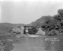
|---|---|
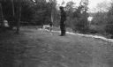
| Description: | A man walks through debris along a metal railing at Cottonwood Villa after an ice storm. The lake, with houses and trees along the shoreline are in the bac... |
| Date: | 1922 |
|---|---|
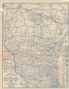
| Description: | This map shows roads, highways, lakes, rivers, county boundaries, and cities. Selected businesses are highlighted in red. Includes an explanation of state ... |
If you didn't find the material you searched for, our Library Reference Staff can help.
Call our reference desk at 608-264-6535 or email us at: