 Filter: Categories of Wisconsin Historical Images
Filter: FULL_DATE of 1922
Filter: Type of Map or Atlas
Filter: Creator Name of Unknown
Filter: Categories of Wisconsin Historical Images
Filter: FULL_DATE of 1922
Filter: Type of Map or Atlas
Filter: Creator Name of Unknown
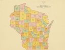
| Date: | 1922 |
|---|---|
| Description: | A map of Wisconsin showing the state’s Assembly Districts. It also provides the population total of each county. |
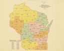
| Date: | 1922 |
|---|---|
| Description: | A map of Wisconsin showing the state’s congressional districts, it also provides the population total for the state, each district and each county. |
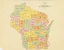
| Date: | 1922 |
|---|---|
| Description: | A map of Wisconsin showing the state’s Senate districts, it also provides the population total for each county. |
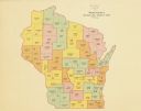
| Date: | 1922 |
|---|---|
| Description: | A map of Wisconsin showing the state’s judicial districts, it also provides the population total for each county. |

| Date: | 1922 |
|---|---|
| Description: | A bird's-eye map that shows the Milwaukee Parkway as contemplated by the Milwaukee County Planning Commission. The map identifies the roads and parks throu... |

| Date: | 1922 |
|---|---|
| Description: | This map shows public libraries, state traveling libraries, and county traveling libraries. County boundaries are labeled. Lake Michigan is on the far righ... |
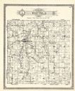
| Date: | 1922 |
|---|---|
| Description: | A plat map by Westfield created by George A. Ogle & Co. |
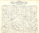
| Date: | 1922 |
|---|---|
| Description: | A plat map of the Township of Honey Creek, created by Geo. A. Ogle & Co. |

| Date: | 1922 |
|---|---|
| Description: | A plat map of the township of Delton near the Wisconsin River. |
If you didn't find the material you searched for, our Library Reference Staff can help.
Call our reference desk at 608-264-6535 or email us at: