 Filter: Categories of Wisconsin Historical Images
Filter: FULL_DATE of 1921
Filter: Subject of railroads
Filter: Categories of Wisconsin Historical Images
Filter: FULL_DATE of 1921
Filter: Subject of railroads
| Date: | 1921 |
|---|---|
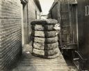
| Description: | A cotton bale sits on a platform next to a train, possibly awaiting shipment. |
| Date: | 1921 |
|---|---|
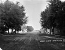
| Description: | View down a tree-lined dirt road. Houses and shops line both sides of the road, and men and children are sitting and playing on the sidewalks. In the far d... |

| Date: | 1921 |
|---|---|
| Description: | This map has labeled streets and points of interest. Lake Mendota and Lake Monona are labeled. The back of the map includes index of University of Wisconsi... |

| Date: | 1921 |
|---|---|
| Description: | This map shows counties, roads, Lake Superior, Lake Michigan, and portions of surrounding states. Included is an index to cities, villages and other places... |

| Date: | 1921 |
|---|---|
| Description: | This map, oriented with north to the upper right, shows roads, railroads, and points of interest. Lake Mendota, Wingra, Monona, Waubesa, Mud, Hook, Island,... |

| Date: | 1921 |
|---|---|
| Description: | This map shows in red the NorthWestern Railway Line routes running from Chicago, Illinois to northern Wisconsin and Michigan. The map includes cities and t... |

| Date: | 1921 |
|---|---|
| Description: | A plat map of Mequon, Wisconsin. Text at top reads: "T. 9N. R.21 E MEQUON T. 9N. R.22 E." |
If you didn't find the material you searched for, our Library Reference Staff can help.
Call our reference desk at 608-264-6535 or email us at:
