 Filter: Categories of Wisconsin Historical Images
Filter: FULL_DATE of 1921
Filter: Reproduction Rights of For Sale
Filter: Subject of rivers
Filter: Categories of Wisconsin Historical Images
Filter: FULL_DATE of 1921
Filter: Reproduction Rights of For Sale
Filter: Subject of rivers
| Date: | 1921 |
|---|---|
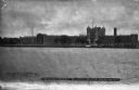
| Description: | View across river toward the exterior of the prison, with the central tower and wings. A boat sits at the dock on the far shoreline, and a large smokestack... |
| Date: | 1921 |
|---|---|
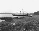
| Description: | A man and a child pose on the dock of a paddle ferry boat named "Dewey." An American flag is affixed to the boat, there is a bell attached on a platform ne... |
| Date: | 1921 |
|---|---|
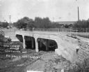
| Description: | View from opposite bank of two horse-drawn buggies crossing the newly constructed bridge over a river. |
| Date: | 1921 |
|---|---|
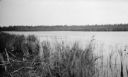
| Description: | A view of the Mink River estuary with marsh grasses in the foreground. |
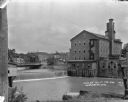
| Date: | 1921 |
|---|---|
| Description: | View from shoreline over the Baraboo River towards a dam, with a mill on the opposite shoreline. A bridge and a business district are in the background. |

| Date: | 1921 |
|---|---|
| Description: | Map reads: "1918. Revised 1921." Key to the map in upper right hand corner reads: "Residential Districts," "Local Businesses," "Commercial and Light Manufa... |
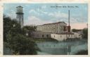
| Date: | 1921 |
|---|---|
| Description: | Colorized postcard view of the exterior of the woolen mill along the banks of a river. A water tower is on the left, and a smokestack is on the right. Capt... |

| Date: | 1921 |
|---|---|
| Description: | This map is part of the survey of the northern and northwestern lakes. The map shows Sheboygan Harbor on the shore of Lake Michigan and the Sheboygan River... |

| Date: | 1921 |
|---|---|
| Description: | This map shows Lake Michigan, the Sheboygan River, buildings, streets, churches, industrial yards, and parks. Relief is shown by hachures and depths are sh... |

| Date: | 1921 |
|---|---|
| Description: | This map shows counties, roads, Lake Superior, Lake Michigan, and portions of surrounding states. Included is an index to cities, villages and other places... |

| Date: | 1921 |
|---|---|
| Description: | This map shows various zones in a proposed city ordinance. Also shown are creeks, streets, parks, hospitals, cemeteries, and the Fox River. A legend is inc... |

| Date: | 1921 |
|---|---|
| Description: | This map, oriented with north to the upper right, shows roads, railroads, and points of interest. Lake Mendota, Wingra, Monona, Waubesa, Mud, Hook, Island,... |

| Date: | 1921 |
|---|---|
| Description: | This map shows selected streets, public buildings, churches, schools, businesses, warehouses, the harbor, the Root River, and Lake Michigan. The map includ... |

| Date: | 1921 |
|---|---|
| Description: | This map shows in red the NorthWestern Railway Line routes running from Chicago, Illinois to northern Wisconsin and Michigan. The map includes cities and t... |

| Date: | 1921 |
|---|---|
| Description: | View across field towards a bend in the Shullsburg Branch, which runs from the Galena River near the town of Lead Mine to the town of Shullsburg. A farm is... |

| Date: | 1921 |
|---|---|
| Description: | A plat map of Mequon, Wisconsin. Text at top reads: "T. 9N. R.21 E MEQUON T. 9N. R.22 E." |
If you didn't find the material you searched for, our Library Reference Staff can help.
Call our reference desk at 608-264-6535 or email us at:
