 Filter: Categories of Wisconsin Historical Images
Filter: FULL_DATE of 1920
Filter: Subject of trails
Filter: Categories of Wisconsin Historical Images
Filter: FULL_DATE of 1920
Filter: Subject of trails

| Date: | 1920 |
|---|---|
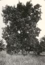
| Description: | View of a supposed Indian "trail tree," on former Mercer's addition or subdivision, now the corner of Elm and Van Hise Streets near Madison West High Schoo... |
| Date: | 1920 |
|---|---|
| Description: | View of a supposed Indian "trail tree," on former Mercer's addition or subdivision, now the corner of Chestnut and Van Hise Streets, near Madison West High... |

| Date: | 1920 |
|---|---|
| Description: | View of a supposed Indian "trail tree" on former Mercer's addition or subdivision, now the corner of Chestnut and Van Hise Streets, near Madison West High ... |
| Date: | 1920 |
|---|---|
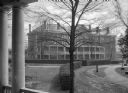
| Description: | View from the porch of Upshaw Hall toward Tift Hall, completed in 1904. The buildings were erected on the campus of Bessie Tift College, founded in 1849. |
| Date: | 1920 |
|---|---|
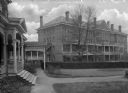
| Description: | Exterior of Addie Upshaw Hall, completed in 1904. The building was erected on the campus of Bessie Tift College, founded in 1849. On the far left, a set o... |
| Date: | 1920 |
|---|---|
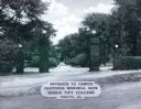
| Description: | A view of the Carithers Memorial Gate at the entrance to the Bessie Tift College campus, consisting of four brick pillars with globe lamps on top flanking ... |

| Date: | 1920 |
|---|---|
| Description: | Shows 10 land and water trails along rivers and other bodies of water in northern Wisconsin and the Upper Peninsula of Michigan; each trail numbered and de... |

| Date: | 1920 |
|---|---|
| Description: | A pedestrian path along the Wisconsin River. An advertisement for J.M. Brophy general store is painted on the rock formations along the path. |

| Date: | 1920 |
|---|---|
| Description: | This map of Devil's Lake State Park in Sauk County, Wisconsin, shows the park limits, railroads, roads, creeks, trails, and points of interest in the area.... |

| Date: | 1920 |
|---|---|
| Description: | This map shows the range of hills crossed by Portage. Also shows the location of sandstone, conglomerate rocks, and the Portage trail. Includes manuscript ... |

| Date: | 1920 |
|---|---|
| Description: | This map shows lands owned by the American Immigration Company (red) and the Homeseekers Land Company (green). The map also shows highways, roads, railroad... |

| Date: | 1920 |
|---|---|
| Description: | Text on front reads: "In Cold Water Canyon, Dells of the Wisconsin." Steps and a path next to a stream in Cold Water Canyon. The scene is fully wooded and ... |
If you didn't find the material you searched for, our Library Reference Staff can help.
Call our reference desk at 608-264-6535 or email us at: