 Filter: Categories of Wisconsin Historical Images
Filter: FULL_DATE of 1920
Filter: Subject of streams
Filter: Categories of Wisconsin Historical Images
Filter: FULL_DATE of 1920
Filter: Subject of streams
| Date: | 1920 |
|---|---|
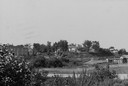
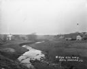
| Description: | View from shoreline of Duncan Creek, with an old dam and on the oppostie shoreline, the residence of Fred Adler, the owner of a brewery and a store in the ... |
| Date: | 1920 |
|---|---|
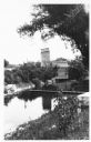
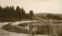
| Description: | View from hill towards the Small mill, with adjacent stream. |
| Date: | 1920 |
|---|---|
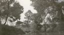
| Description: | View across water towards the C.R. Pickering Camp on Mill Creek, in summer. The shelter is on a hill overlooking the pond. |
| Date: | 1920 |
|---|---|
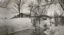
| Description: | C.R. Pickering Camp on Mill Creek, in winter with snow on the ground. On the opposite shoreline is a shelter on the hill overlooking the creek, with a set ... |
| Date: | 1920 |
|---|---|
| Description: | View from low hill of a stream flowing through fields. There are cows in the pasture on the right. In the distance is a bridge, road, and buildings. |
| Date: | 1920 |
|---|---|
| Description: | View along shoreline towards a rustic foot bridge which crosses the mouth of Fish Creek, which separates the village of Fish Creek from Peninsula State Par... |
| Date: | 1920 |
|---|---|
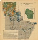
| Description: | This map shows the township and range system, sections, cities and villages, railroads, roads, and streams and lakes in Oconto County, Wisconsin. Color co... |

| Date: | 1920 |
|---|---|
| Description: | This map of Sawyer County, Wisconsin, from the early 20th century shows the township and range system, towns, sections, cities and villages, railroads, hig... |
| Date: | 1920 |
|---|---|
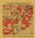
| Description: | This early-20th century map of the towns of Round Lake and Spider Lake, Sawyer County, Wisconsin, shows sections, roads, lake and streams, and land owned a... |

| Date: | 1920 |
|---|---|
| Description: | This manuscript map of southern Bayfield County, Wisconsin, covers the towns of Cable and Drummond and portions of Grandview and Namekagon. Shown are the t... |

| Date: | 1920 |
|---|---|
| Description: | This 1920 map of Forest County, Wisconsin, shows the township and range grid, sections, cities and villages, lakes and streams, roads, "steam railroads," s... |

| Date: | 1920 |
|---|---|
| Description: | A tree-lined rock face next to Duncan Creek in Irvine Park in Chippewa Falls. Caption reads: "A Beautiful Scene in Irvine Park, Chippewa Falls, Wis." |

| Date: | 1920 |
|---|---|
| Description: | A man is walking across a narrow suspension bridge over a spillway or dam. A typewritten note on the reverse reads: "Honey Creek, West of Sauk City, Many S... |

| Date: | 1920 |
|---|---|
| Description: | Text on front reads: "Springtime in Artist's Glen, Dells of the Wisconsin River." Trees and flowers surround a stream with a rocky bank. |

| Date: | 1920 |
|---|---|
| Description: | Text on front reads: "In Cold Water Canyon, Dells of the Wisconsin." Steps and a path next to a stream in Cold Water Canyon. The scene is fully wooded and ... |
If you didn't find the material you searched for, our Library Reference Staff can help.
Call our reference desk at 608-264-6535 or email us at: