 Filter: Categories of Wisconsin Historical Images
Filter: FULL_DATE of 1920
Filter: Subject of state parks and reserves
Filter: Categories of Wisconsin Historical Images
Filter: FULL_DATE of 1920
Filter: Subject of state parks and reserves
| Date: | 1920 |
|---|---|
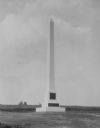
| Description: | Cushing Memorial, erected on the S.E. 1/4 of S.W. 1/4 of Section 18. |

| Date: | 1920 |
|---|---|
| Description: | View from shoreline of a water slide at Mirror Lake State Park. A woman rides down the slide into the lake, and a few people stand on the platform behind h... |
| Date: | 1920 |
|---|---|
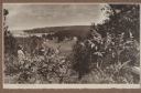
| Description: | A well-dressed man identified as Uncle Rudolph Schenck takes in the view from a bluff overlooking the Fish Creek valley and harbor. There are houses and ou... |
| Date: | 1920 |
|---|---|
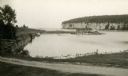
| Description: | Several boats are moored in the protected harbor. An old warehouse stands on a pier. A tall bluff and rock cliff dominates the opposite shoreline. |

| Date: | 1920 |
|---|---|
| Description: | A map of the Nelson-Dewey State Park at the confluence of the Mississippi and Wisconsin rivers, showing the topographical features of the area, as well as ... |

| Date: | 1920 |
|---|---|
| Description: | This 1920 map actually depicts present-day Wyalusing State Park at the confluence of the Mississippi and Wisconsin rivers in the Town of Wyalusing, Grant C... |

| Date: | 1920 |
|---|---|
| Description: | This early 1920s map shows state-owned land in townships 38 and 39, range 7 east, the towns of Lake Tomahawk and Woodruff, in Oneida County, Wisconsin, tha... |

| Date: | 1920 |
|---|---|
| Description: | This map of Devil's Lake State Park in Sauk County, Wisconsin, shows the park limits, railroads, roads, creeks, trails, and points of interest in the area.... |

| Date: | 1920 |
|---|---|
| Description: | Man and woman stand in a forest at the base of a large maple tree, 20 feet in circumference. They are reaching their arms towards each other to show the wi... |
| Date: | 1920 |
|---|---|
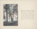
| Description: | A hand-tinted photograph of a scene along the wooded shore of Devil's Lake is mounted on a piece of beige paper. The scene features an old section of a woo... |
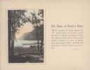
| Date: | 1920 |
|---|---|
| Description: | A hand-tinted photograph of a tree-framed scene along the shore of Devil's Lake is mounted on a piece of beige paper. A large bluff dominates the backgroun... |
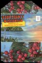
| Date: | 1920 |
|---|---|
| Description: | Envelope cover. Inside are eighteen color enhanced photographic scenes from Door County, Wisconsin, including a short description of Door County features t... |

| Date: | 1920 |
|---|---|
| Description: | This blue print map shows landownership between 1913 and 1916, topography, railroads, and roads. The map covers the vicinity of Perrot State Park. |
If you didn't find the material you searched for, our Library Reference Staff can help.
Call our reference desk at 608-264-6535 or email us at: