Filter: Categories of Wisconsin Historical Images
Filter: FULL_DATE of 1920
Filter: Subject of human settlements
Filter: Subject of michigan, lake
Filter: Categories of Wisconsin Historical Images
Filter: FULL_DATE of 1920
Filter: Subject of human settlements
Filter: Subject of michigan, lake
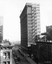
| Date: | 1920 |
|---|---|
| Description: | Elevated view of the International Harvester building, as seen from the northwest. Lake Michigan is in the background. |
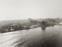
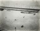
| Date: | 1920 |
|---|---|
| Description: | Aerial view of with bridges, river, and shoreline. |

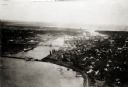
| Date: | 1920 |
|---|---|
| Description: | View across water towards a grain elevator on the site of the old Elmore & Kelly's elevator. |
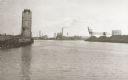
| Date: | 1920 |
|---|---|
| Description: | View of the harbor. On the left is a grain elevator and wood pulp on the wharf. In the center background is the Northern Paper Mills and to the right are ... |
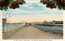
| Date: | 1920 |
|---|---|
| Description: | View of two automobiles crossing a toll bridge. There are cherries on branches at the top of the postcard. Caption reads: "In Door County 'Cherryland,' The... |
| Date: | 1920 |
|---|---|
| Description: | Elevated view from a window of the International Harvester offices on Michigan Avenue showing Grant Park. Company employees have written their department n... |
| Date: | 1920 |
|---|---|
| Description: | Elevated view from a window of the International Harvester offices on Michigan Avenue showing Grant Park. Company employees have written their department n... |

| Date: | 1920 |
|---|---|
| Description: | This map shows wards, streets, railroads, parks, cemeteries, select buildings, and Lake Michigan. Also included is a street index. Cemeteries and parks are... |

| Date: | 1920 |
|---|---|
| Description: | This map shows the numbered state trunk highways, county boundaries, cities, rivers and lakes. Lake Michigan is on the far left, with Lake Superior at the ... |

| Date: | 1920 |
|---|---|
| Description: | This map details automobile routes spanning across Wisconsin and parts of Illinois, Michigan, Minnesota, and Iowa. Cities, counties, Lake Michigan, Lake Su... |

| Date: | 1920 |
|---|---|
| Description: | This map shows the entire state as well as portions of Iowa, Illinois, Minnesota, and Michigan. Counties outlined in yellow, cities, rivers, lakes, and rai... |

| Date: | 1920 |
|---|---|
| Description: | The map shows the entire state with cities, rivers, and lakes labeled. The upper and right margin include inset maps of Racine, Milwaukee, Waukesha, Applet... |

| Date: | 1920 |
|---|---|
| Description: | This map of the entire state shows state and other highways, cities, some lake, the Mississippi River, Lake Michigan, and Lake Superior. The bottom left co... |
If you didn't find the material you searched for, our Library Reference Staff can help.
Call our reference desk at 608-264-6535 or email us at: