 Filter: Categories of Wisconsin Historical Images
Filter: FULL_DATE of 1920
Filter: Subject of human settlements
Filter: Subject of lakes
Filter: Categories of Wisconsin Historical Images
Filter: FULL_DATE of 1920
Filter: Subject of human settlements
Filter: Subject of lakes

| Date: | 1920 |
|---|---|
| Description: | View of the Wisconsin State Capitol from Lake Monona prior to the building of the State Office Building at 1 West Wilson Street in 1923. |
| Date: | 1920 |
|---|---|
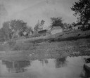
| Description: | View of farm buildings in the background on the top of a hill, with the shore of the lake in the foreground. |
| Date: | 1920 |
|---|---|
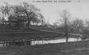
| Description: | View across pond looking towards the Buena Vista house on Lake de Neveu. Caption reads: "The House Buena Vista The de Neveu Farm". |

| Date: | 1920 |
|---|---|
| Description: | View looking down hill towards the Buena Vista house on Lake de Neveu. Caption reads: "The House Buena Vista The de Neveu Farm". |
| Date: | 1920 |
|---|---|
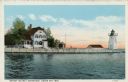
| Description: | View across water toward the lighthouse. Caption reads: "Grassy Island Lighthouse, Green Bay, Wis." |

| Date: | 1920 |
|---|---|
| Description: | Elevated view toward Lake Mendota towards the City Boathouse, which was designed by Frank Lloyd Wright. The boathouse was at the foot of North Carroll Stre... |

| Date: | 1920 |
|---|---|
| Description: | A map of Madison and the vicinity. Red lines show the street railway. |

| Date: | 1920 |
|---|---|
| Description: | Calumet Harbor on Lake Winnebago. On the left is a map, and on the right are two images, one captioned: "Calumet Harbor". |

| Date: | 1920 |
|---|---|
| Description: | The house was built in the late 1850s or early 1860s by Donnel and Kutzbock, who also built the first Wisconsin State Capitol in Madison. Originally this h... |

| Date: | 1920 |
|---|---|
| Description: | View along the steep shoreline of possibly Lake Mendota. In the foreground there is a veranda looking over the lake with various docks and boats in the bac... |

| Date: | 1920 |
|---|---|
| Description: | Elevated view across Langdon Street of the Armory (Red Gym or Old Red) on campus of University of Wisconsin-Madison. There is a large boathouse behind the ... |
| Date: | 1920 |
|---|---|
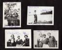
| Description: | A page from the Webb family album, compiled and captioned by Andrew Webb Jr., son of Caroline Webb, with four images of family friends, including two young... |

| Date: | 1920 |
|---|---|
| Description: | A two-sided map of the state of Wisconsin. The front includes towns and major cities as well as state and county trunk highways. The back includes a smalle... |
| Date: | 1920 |
|---|---|
| Description: | This map shows the township and range system, sections, cities and villages, railroads, roads, and streams and lakes in Oconto County, Wisconsin. Color co... |

| Date: | 1920 |
|---|---|
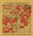
| Description: | This early 1920s map shows state-owned land in townships 38 and 39, range 7 east, the towns of Lake Tomahawk and Woodruff, in Oneida County, Wisconsin, tha... |

| Date: | 1920 |
|---|---|
| Description: | This map of Sawyer County, Wisconsin, from the early 20th century shows the township and range system, towns, sections, cities and villages, railroads, hig... |
| Date: | 1920 |
|---|---|
| Description: | This early-20th century map of the towns of Round Lake and Spider Lake, Sawyer County, Wisconsin, shows sections, roads, lake and streams, and land owned a... |

| Date: | 1920 |
|---|---|
| Description: | This map shows the township and range system, sections, schools, churches, cemeteries, town halls, roads, railroads, and lakes and streams in Shawano Count... |
| Date: | 1920 |
|---|---|
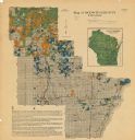
| Description: | This early 20th century map shows the soil types in Vilas County, Wisconsin, and adjoining areas in Oneida, Forest, Iron, and Price counties. Also depicted... |

| Date: | 1920 |
|---|---|
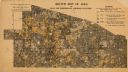
| Description: | This manuscript map of southern Bayfield County, Wisconsin, covers the towns of Cable and Drummond and portions of Grandview and Namekagon. Shown are the t... |
If you didn't find the material you searched for, our Library Reference Staff can help.
Call our reference desk at 608-264-6535 or email us at: