 Filter: Categories of Wisconsin Historical Images
Filter: FULL_DATE of 1920
Filter: Subject of automobile driving
Filter: Categories of Wisconsin Historical Images
Filter: FULL_DATE of 1920
Filter: Subject of automobile driving
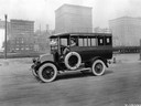
| Date: | 1920 |
|---|---|
| Description: | Man drives an International bus on a city street. |
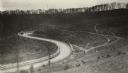
| Date: | 1920 |
|---|---|
| Description: | Loganville Road in Sauk County taken by the Wisconsin Good Roads Association. The photograph was meant to create a contrast between the new improved road ... |
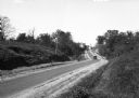
| Date: | 1920 |
|---|---|
| Description: | View looking down the National Pike Highway, featuring an oncoming car, and buildings in the distance. |

| Date: | 1920 |
|---|---|
| Description: | View down cobblestone street in the business district numerous cars, pedestrians, and storefronts. Cars are parked at an angle on both sides of the street. |

| Date: | 1920 |
|---|---|
| Description: | A two-sided map of the state of Wisconsin. The front includes towns and major cities as well as state and county trunk highways. The back includes a smalle... |
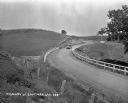
| Date: | 1920 |
|---|---|
| Description: | View from hillside of car driving down a winding road. Their are cornfields on both sides of the road. |

| Date: | 1920 |
|---|---|
| Description: | View from shoreline of three people in a car on a bridge over the Wisconsin River. |

| Date: | 1920 |
|---|---|
| Description: | This early road map shows the system of roads in Wisconsin, northern Illinois, northeastern Iowa, southeastern Minnesota, and the western portion of Michig... |

| Date: | 1920 |
|---|---|
| Description: | This map details automobile routes spanning across Wisconsin and parts of Illinois, Michigan, Minnesota, and Iowa. Cities, counties, Lake Michigan, Lake Su... |

| Date: | 1920 |
|---|---|
| Description: | This map shows the entire state as well as portions of Iowa, Illinois, Minnesota, and Michigan. Counties outlined in yellow, cities, rivers, lakes, and rai... |

| Date: | 1920 |
|---|---|
| Description: | The map shows the entire state with cities, rivers, and lakes labeled. The upper and right margin include inset maps of Racine, Milwaukee, Waukesha, Applet... |
If you didn't find the material you searched for, our Library Reference Staff can help.
Call our reference desk at 608-264-6535 or email us at: