Filter: Categories of Wisconsin Historical Images
Filter: FULL_DATE of 1920
Filter: Type of Map or Atlas
Filter: Subject of human settlements
Filter: Categories of Wisconsin Historical Images
Filter: FULL_DATE of 1920
Filter: Type of Map or Atlas
Filter: Subject of human settlements
| Date: | 1920 |
|---|---|
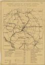
| Description: | This map produced just after Word War I shows the proposed location for a veterans' hospital in the Eau Claire-Chippewa Falls region. Highways, rail lines ... |

| Date: | 1920 |
|---|---|
| Description: | This map of Sawyer County, Wisconsin, from the early 20th century shows the township and range system, towns, sections, cities and villages, railroads, hig... |

| Date: | 1920 |
|---|---|
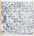
| Description: | This map shows the township and range system, sections, schools, churches, cemeteries, town halls, roads, railroads, and lakes and streams in Shawano Count... |

| Date: | 1920 |
|---|---|
| Description: | Shows lot and block numbers. Includes manuscript annotations showing original Wisconsin Central Railway line in red which reads: "Original W.C. Line in Men... |

| Date: | 1920 |
|---|---|
| Description: | This map shows a small island in the Menominee River and includes a survey table and certification. |
If you didn't find the material you searched for, our Library Reference Staff can help.
Call our reference desk at 608-264-6535 or email us at: