 Filter: Categories of Wisconsin Historical Images
Filter: FULL_DATE of 1919
Filter: Subject of recreation areas
Filter: Categories of Wisconsin Historical Images
Filter: FULL_DATE of 1919
Filter: Subject of recreation areas

| Date: | 1919 |
|---|---|
| Description: | This is a collection of three hand-colored plat maps. One map is a plat plan and includes annotations and an index that shows public land, business, indust... |

| Date: | 1919 |
|---|---|
| Description: | Court House Park from Court Street looking southeast. The Civil War monument can be seen near the center, behind is the old courthouse which was replaced ... |
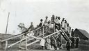
| Date: | 1919 |
|---|---|
| Description: | A group of children posing on and beneath a wooden playground slide. There is a barn in the background. |

| Date: | 1919 |
|---|---|
| Description: | Narrow red lines show principal secondary highways. Green circles shows points of historical interest. Green triangles show Indian mounds and Indian villag... |
If you didn't find the material you searched for, our Library Reference Staff can help.
Call our reference desk at 608-264-6535 or email us at: