 Filter: Categories of Wisconsin Historical Images
Filter: FULL_DATE of 1919
Filter: Subject of lakes
Filter: Categories of Wisconsin Historical Images
Filter: FULL_DATE of 1919
Filter: Subject of lakes

| Date: | 1919 |
|---|---|
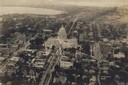
| Description: | Colorized aerial view of isthmus looking northwest over the Wisconsin State Capitol. Caption reads: "Aeroplane View, Madison, Wis., and State Capitol." |

| Date: | 1919 |
|---|---|
| Description: | Aerial view from King Street looking southwest to the University of Wisconsin campus. |

| Date: | 1919 |
|---|---|
| Description: | Aerial view with the Wisconsin State Capitol in the foreground, and the tip of Monona Bay and Lake Wingra to the left, with horizon stretching into the dis... |
| Date: | 1919 |
|---|---|
| Description: | Aerial view of the Capitol Square and surrounding area. Lake Monona and Lake Wingra are in the background. |
| Date: | 1919 |
|---|---|
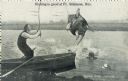
| Description: | Photomontage of a fisherman in a rowboat catching a giant turtle. The male companion of the fisherman has fallen in and lost his hat amidst the excitement.... |
| Date: | 1919 |
|---|---|
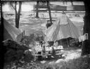
| Description: | Elevated view of the Herman Taylor family camping at Devil's Lake. There is a moving train in the background on railroad tracks along the shoreline of the ... |

| Date: | 1919 |
|---|---|
| Description: | This 1919 map of Sawyer County, Wisconsin, shows the township and range system, sections, cities and villages, roads, railroads, farm houses, the Indian re... |

| Date: | 1919 |
|---|---|
| Description: | This map shows details of the harbor, proposed route and bridge changes, railroads, streets, selected buildings, a portion of Lake Superior and other lakes... |

| Date: | 1919 |
|---|---|
| Description: | Narrow red lines show principal secondary highways. Green circles shows points of historical interest. Green triangles show Indian mounds and Indian villag... |

| Date: | 1919 |
|---|---|
| Description: | This map contains the automobile routes in southern Wisconsin and northern Illinois. Cities, Lake Winnebago and Green Bay are labeled. The orange print on ... |

| Date: | 1919 |
|---|---|
| Description: | Aerial view looking north over Lake Monona towards the Wisconsin State Capitol on the isthmus. Lake Mendota is in the background. |

| Date: | 1919 |
|---|---|
| Description: | Aerial view of the Isthmus and Lake Mendota from over Lake Monona. The Wisconsin State Capitol is in the center. |

| Date: | 1919 |
|---|---|
| Description: | Aerial view of the Wisconsin State Capitol and the square from over King Street. Lake Mendota is on the right. The State Historical Society is at the end o... |
If you didn't find the material you searched for, our Library Reference Staff can help.
Call our reference desk at 608-264-6535 or email us at: