 Filter: Categories of Wisconsin Historical Images
Filter: FULL_DATE of 1917
Filter: Subject of lakes
Filter: Categories of Wisconsin Historical Images
Filter: FULL_DATE of 1917
Filter: Subject of lakes
| Date: | 1917 |
|---|---|
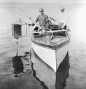
| Description: | Edward A. Birge and Chancey Juday with plankton trap in Lake Mendota. From album of photographs relating to the research in limnology conducted at Trout La... |

| Date: | 1917 |
|---|---|
| Description: | Brick house at 640 North Frances Street, erected in 1906 for the Delta Upsilon Fraternity. |
| Date: | 1917 |
|---|---|
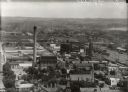
| Description: | View from Capitol dome east to Third Lake Ridge District. Power plant is visible at center. Lake Monona is on the right. |

| Date: | 1917 |
|---|---|
| Description: | Colorized view of King Street as seen from the Capitol grounds. Caption reads: "Looking Toward King Street from the Capitol, Madison, Wis." |

| Date: | 1917 |
|---|---|
| Description: | The Lake Forest community plan, a model community that was planned for the site where the University of Wisconsin Arboretum now stands. |

| Date: | 1917 |
|---|---|
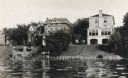
| Description: | A view of the shore, looking southeast from Lake Mendota. At left is the Thomas E. Brittingham residence and boathouse, 640 North Henry Street; center is ... |
| Date: | 1917 |
|---|---|
| Description: | A view of the shore, looking southeast from Lake Mendota. At left is the Thomas E. Brittingham residence and boathouse, 640 North Henry Street; center is ... |
| Date: | 1917 |
|---|---|
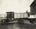
| Description: | Man loading ice from loading dock with an International Model F (or 31) truck. The truck was operated by the Hudson/Willow River Ice Company. There is a la... |

| Date: | 1917 |
|---|---|
| Description: | A group standing on a Lake Monona pier with a large toy sail boat. Richard "Dick" Lloyd Jones is at far left, his mother, Georgia Lloyd Jones stands to th... |
| Date: | 1917 |
|---|---|
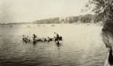
| Description: | University of Wisconsin-Madison students play on a canoe in Lake Mendota near the campus. |
| Date: | 1917 |
|---|---|
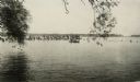
| Description: | University of Wisconsin-Madison students stand on a Lake Mendota pier while others paddle a canoe. |
| Date: | 1917 |
|---|---|
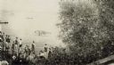
| Description: | University of Wisconsin-Madison students stand on a Lake Mendota pier watching others swim. |
| Date: | 1917 |
|---|---|
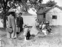
| Description: | A group of people under a tree in a farmyard, with possibly a lake in the background. Two women, with heavy netting on their hats, hold luggage. A toddler ... |

| Date: | 1917 |
|---|---|
| Description: | Bird's-eye view of the University of Wisconsin-Madison campus. |
| Date: | 1917 |
|---|---|
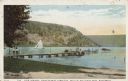
| Description: | Colorized postcard of the pier landing as seen from the tourist camp site in Devil's Lake State Park. People are strolling on the dock, a boat is docked, w... |

| Date: | 1917 |
|---|---|
| Description: | A geological survey map that shows the sedimentary and igneous deposits in southeastern Wisconsin and south central Wisconsin, as well as the limits of gla... |

| Date: | 1917 |
|---|---|
| Description: | A geological survey map of southeastern Wisconsin that shows the configuration of the bedrock beneath the glacial drift and other deposits in southeastern ... |

| Date: | 1917 |
|---|---|
| Description: | A geological survey map that map of southeastern Wisconsin shows the surface deposits east of the Wisconsin River, from the Illinois state line north to Ne... |

| Date: | 1917 |
|---|---|
| Description: | This map, which highlights the land for sale by the Rust-Owen Lumber Company in the towns of Drummond, Cable and Grandview, Bayfield County, Wisconsin, sho... |

| Date: | 1917 |
|---|---|
| Description: | This 1917 map of Bayfield County, Wisconsin, shows the township and range system, towns, sections, cities and villages, railroads, wagon roads, and lakes a... |
If you didn't find the material you searched for, our Library Reference Staff can help.
Call our reference desk at 608-264-6535 or email us at: