 Filter: Categories of Wisconsin Historical Images
Filter: FULL_DATE of 1916
Filter: Subject of transportation
Filter: Categories of Wisconsin Historical Images
Filter: FULL_DATE of 1916
Filter: Subject of transportation

| Date: | 1916 |
|---|---|
| Description: | This map shows Chequamegon Bay, an inlet of Lake Superior. Depths are shown by isolines and soundings and relief shown by contours. The map is colored in y... |

| Date: | 1916 |
|---|---|
| Description: | Water of Big Bull Falls or the Wisconsin River rapidly flows underneath two railroad bridges. Pedestrians cross the bridges while peering over at the over... |

| Date: | 1916 |
|---|---|
| Description: | Hand-colored postcard view from across street towards the Chippewa Falls High School on North Bridge Street. Caption reads: "High School, Chippewa Falls, W... |
| Date: | 1916 |
|---|---|
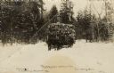
| Description: | Black and white photographic postcard of a horse-drawn sled loaded with logs coming out of the woods. One or two men are driving the sled, and a man is wal... |

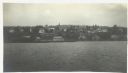
| Date: | 1916 |
|---|---|
| Description: | Elevated view from hill looking towards Nagawicka Lake. There is a road and buildings along the shoreline at the bottom of the hill. There are a number of ... |

| Date: | 1916 |
|---|---|
| Description: | A black and white photograph of newly paved Madison Road. It was paved in 1916 with asphalt concrete by Jas. Rasmussen & Sons, Oshkosh, Wisconsin, under th... |

| Date: | 1916 |
|---|---|
| Description: | This map is mounted on cloth and shows lots and roads. An inset map is included that shows towns, lakes, rivers, and railroads within portions of the Dakot... |
| Date: | 1916 |
|---|---|
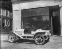
| Description: | Light-colored Ford speedster is parked on the sidewalk in front of Schoelkopf's dealership at 210 E. Washington Avenue. There is a Ford sign in the show wi... |
| Date: | 1916 |
|---|---|
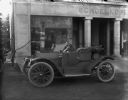
| Description: | Small roadster parked in front of Schoelkopf's dealership at 210 E. Washington Avenue. A man stands near the entrance on the right. On the far left a car i... |

| Date: | 1916 |
|---|---|
| Description: | Ford Model T touring car parked on the street near the Wisconsin State Capitol building. In the background a banner strung above the street in front of the... |
| Date: | 1916 |
|---|---|
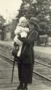
| Description: | Full-length portrait of Elizabeth Baker standing and holding a young girl in her arms. They are next to railroad tracks. |
| Date: | 1916 |
|---|---|
| Description: | View across Lake Superior towards Bayfield. |

| Date: | 1916 |
|---|---|
| Description: | This map shows ward numbers, streets, railroads, electric car lines, parks, steam railways, section numbers, rivers, Lake Michigan, churches, schools, and ... |
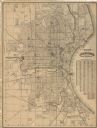
| Date: | 1916 |
|---|---|
| Description: | This map shows wards, roads, railroads, parks, cemeteries, select buildings, and Lake Michigan. Also included is a street index and manuscript annotations ... |

| Date: | 1916 |
|---|---|
| Description: | Rear view of an International Scout, with hood up and doors open, suspended on a jack as it nears its complete assembly. There is a spare tire inside the t... |
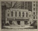
| Date: | 1916 |
|---|---|
| Description: | Drawing of the new Reierson Studio. An arrow leads from the sign painted at the top of the building to the studio door, which is to the right of the storef... |

| Date: | 1916 |
|---|---|
| Description: | This map shows highways, roads, routes, communities, rivers, and lakes. Wide red lines show principle highways. Narrow red lines show secondary roadways or... |
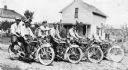
| Date: | 1916 |
|---|---|
| Description: | Excelsior Twin Motorcycles with, left to right: Stroh Brothers, Mart Liedtke, William Martin, Mr. Schultz, and Mr. Liedtke. |
| Date: | 1916 |
|---|---|
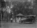
| Description: | A group of a man, two women and two children playing croquet next to an automobile and a gazebo in a park. |

| Date: | 1916 |
|---|---|
| Description: | This map shows railroads, cities, rivers, lakes, and county boundaries. Select railroads are outlined in red. Portions of western Wisconsin Minnesota are v... |
If you didn't find the material you searched for, our Library Reference Staff can help.
Call our reference desk at 608-264-6535 or email us at: