 Filter: Categories of Wisconsin Historical Images
Filter: FULL_DATE of 1916
Filter: Subject of transportation
Filter: Community of Milwaukee
Filter: Categories of Wisconsin Historical Images
Filter: FULL_DATE of 1916
Filter: Subject of transportation
Filter: Community of Milwaukee
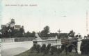
| Date: | 1916 |
|---|---|
| Description: | South entrance to park. The bridge has stone lion sculptures on each of its corners, as well as ornate street lamps. A lighthouse and attached buildings ar... |
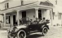
| Date: | 1916 |
|---|---|
| Description: | Three people sitting in the back seat of a parked car drinking beer and other beverages in glasses. The building behind them is the Otto Sprenger Millersvi... |

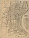
| Date: | 1916 |
|---|---|
| Description: | This map shows ward numbers, streets, railroads, electric car lines, parks, steam railways, section numbers, rivers, Lake Michigan, churches, schools, and ... |
| Date: | 1916 |
|---|---|
| Description: | This map shows wards, roads, railroads, parks, cemeteries, select buildings, and Lake Michigan. Also included is a street index and manuscript annotations ... |
If you didn't find the material you searched for, our Library Reference Staff can help.
Call our reference desk at 608-264-6535 or email us at: