Filter: Categories of Wisconsin Historical Images
Filter: FULL_DATE of 1916
Filter: Subject of rivers
Filter: Categories of Wisconsin Historical Images
Filter: FULL_DATE of 1916
Filter: Subject of rivers

| Date: | 1916 |
|---|---|
| Description: | Southeastern Wisconsin which lies east of Whitewater and south of Port Washington. |
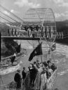
| Date: | 1916 |
|---|---|
| Description: | Slightly elevated view of people in the Whirlpool Aero Car, opened in 1916, departing from the station and crossing the whirlpool of Niagara Falls. |

| Date: | 1916 |
|---|---|
| Description: | A pen on paper, hand-drawn map that shows the railroads, rivers, county outlines, and cities and villages in Wisconsin, northern Illinois, and the western ... |

| Date: | 1916 |
|---|---|
| Description: | In 1916, it was estimated that 15,000 Indian mounds had formerly existed in Wisconsin. In the early 20th century, the Wisconsin Archaeological Society surv... |
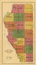
| Date: | 1916 |
|---|---|
| Description: | This early 20th century map of Adams County, Wisconsin, shows the township and range grid, towns, sections, cities and villages, roads, railroads, lakes an... |

| Date: | 1916 |
|---|---|
| Description: | Includes index to businesses, churches, and schools. Shows local streets, buildings, railroads, ward divisions, Fond du Lac River, and part of Lake Winneba... |

| Date: | 1916 |
|---|---|
| Description: | Map shows roads, railroads, the Fox River, parks, and cemeteries. Wards are numbered and the edges of the map feature coordinates. The top left of the map ... |
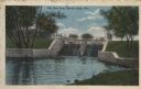
| Date: | 1916 |
|---|---|
| Description: | Colorized postcard view of a dam on a river. There is a factory behind the trees in the background. Caption reads: "The New Dam, Beaver Dam, Wis." |

| Date: | 1916 |
|---|---|
| Description: | This map is mounted on cloth and shows lots and roads. An inset map is included that shows towns, lakes, rivers, and railroads within portions of the Dakot... |

| Date: | 1916 |
|---|---|
| Description: | This map shows ward numbers, streets, railroads, electric car lines, parks, steam railways, section numbers, rivers, Lake Michigan, churches, schools, and ... |

| Date: | 1916 |
|---|---|
| Description: | This map shows highways, roads, routes, communities, rivers, and lakes. Wide red lines show principle highways. Narrow red lines show secondary roadways or... |

| Date: | 1916 |
|---|---|
| Description: | This map shows railroads, cities, rivers, lakes, and county boundaries. Select railroads are outlined in red. Portions of western Wisconsin Minnesota are v... |
| Date: | 1916 |
|---|---|
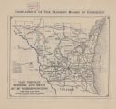
| Description: | The map on the front shows roads from Madison to northern Illinois and as far north as St. Croix, Chippewa, Marathon, and Shawano counties. The map on the ... |
| Date: | 1916 |
|---|---|
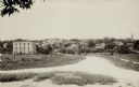
| Description: | View of Grafton from the road leading into town. There is a bridge over the river, and a church is on the far right. Caption reads: "Birdseye [sic] View, G... |
| Date: | 1916 |
|---|---|
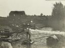
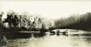
| Description: | A driver of a horse-drawn wagon fords the Chippewa River. |
| Date: | 1916 |
|---|---|
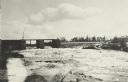
| Description: | A view across the Chippewa River towards the Radisson Dam. |
If you didn't find the material you searched for, our Library Reference Staff can help.
Call our reference desk at 608-264-6535 or email us at: