 Filter: Categories of Wisconsin Historical Images
Filter: FULL_DATE of 1916
Filter: Subject of lakes
Filter: Categories of Wisconsin Historical Images
Filter: FULL_DATE of 1916
Filter: Subject of lakes
| Date: | 1916 |
|---|---|
| Description: | Panoramic view of the Wingra area from the railroad tracks north of Gregory Street. Looking towards Lake Wingra, across Monroe Street. |

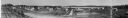
| Date: | 1916 |
|---|---|
| Description: | Elevated view of the town from a boxcar. A railroad train is headed towards a bridge over the lake. Caption reads: The ideal fishing resort of the One Thou... |

| Date: | 1916 |
|---|---|
| Description: | Southeastern Wisconsin which lies east of Whitewater and south of Port Washington. |
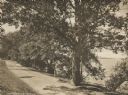
| Date: | 1916 |
|---|---|
| Description: | University Drive along Lake Mendota. Picnic Point can be seen across the lake. Caption reads: "University Drive." |

| Date: | 1916 |
|---|---|
| Description: | In 1916, it was estimated that 15,000 Indian mounds had formerly existed in Wisconsin. In the early 20th century, the Wisconsin Archaeological Society surv... |
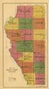
| Date: | 1916 |
|---|---|
| Description: | This early 20th century map of Adams County, Wisconsin, shows the township and range grid, towns, sections, cities and villages, roads, railroads, lakes an... |

| Date: | 1916 |
|---|---|
| Description: | This 1916 map of Washburn County, Wisconsin, shows the township and range grid, sections, towns, schools, wagon roads, cities and villages, post offices, s... |

| Date: | 1916 |
|---|---|
| Description: | Includes index to businesses, churches, and schools. Shows local streets, buildings, railroads, ward divisions, Fond du Lac River, and part of Lake Winneba... |

| Date: | 1916 |
|---|---|
| Description: | Elevated view from hill looking towards Nagawicka Lake. There is a road and buildings along the shoreline at the bottom of the hill. There are a number of ... |

| Date: | 1916 |
|---|---|
| Description: | This map is mounted on cloth and shows lots and roads. An inset map is included that shows towns, lakes, rivers, and railroads within portions of the Dakot... |

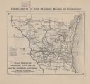
| Date: | 1916 |
|---|---|
| Description: | This map shows highways, roads, routes, communities, rivers, and lakes. Wide red lines show principle highways. Narrow red lines show secondary roadways or... |

| Date: | 1916 |
|---|---|
| Description: | This map shows railroads, cities, rivers, lakes, and county boundaries. Select railroads are outlined in red. Portions of western Wisconsin Minnesota are v... |
| Date: | 1916 |
|---|---|
| Description: | The map on the front shows roads from Madison to northern Illinois and as far north as St. Croix, Chippewa, Marathon, and Shawano counties. The map on the ... |
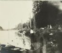
| Date: | 1916 |
|---|---|
| Description: | Jack and Russell Greene go swimming in the lake after setting up camp. There is a canoe in the foreground. |
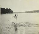
| Date: | 1916 |
|---|---|
| Description: | One of the Greene boys running into the lake. |
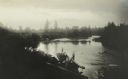
| Date: | 1916 |
|---|---|
| Description: | A view of Bear Lake and the surrounding forested area. Several of The Gang are standing on a dam. |

| Date: | 1916 |
|---|---|
| Description: | Poster depicts First Nations man holding a dollar bill and two coins in one hand and a letter in the other hand written in his language. A paper with the t... |

| Date: | 1916 |
|---|---|
| Description: | Birds-eye view of the University of Wisconsin-Madison campus. The Armory (Red Gym), Science Hall and State Historical Society are in the foreground. Main H... |

| Date: | 1916 |
|---|---|
| Description: | Elevated view down Wisconsin Avenue from the Square. Madison City Hall is on the left. Lake Mendota is in the distance. Caption reads: "Partial View of Mad... |
If you didn't find the material you searched for, our Library Reference Staff can help.
Call our reference desk at 608-264-6535 or email us at:
