 Filter: Categories of Wisconsin Historical Images
Filter: FULL_DATE of 1915
Filter: Subject of transportation
Filter: Subject of intellectual life
Filter: Categories of Wisconsin Historical Images
Filter: FULL_DATE of 1915
Filter: Subject of transportation
Filter: Subject of intellectual life
| Date: | 1915 |
|---|---|
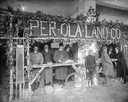
| Description: | Men in hats and coats stand in exhibit booth for the Per-Ola Land Company. |
| Date: | 1915 |
|---|---|
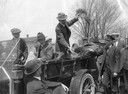
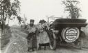
| Description: | Professor Holden of International Harvester's Agricultural Extension Department expounds the benefits of alfalfa from the back seat of a car. |
| Date: | 1915 |
|---|---|
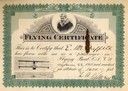
| Description: | Certificate issued to E.M. Griffith, the Wisconsin State Forester, so that Griffith could prove that he had flown at an altitude of 1600 feet in the "flyin... |
| Date: | 1915 |
|---|---|
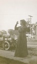
| Description: | Belle Case La Follette, the wife of Robert M. La Follette, Sr., wearing a black dress and hat and speaking outdoors at an unidentified location. |

| Date: | 1915 |
|---|---|
| Description: | Bird's-eye view of Superior, Wisconsin, and Duluth, Minnesota on opposite shore of Lake Superior. |
| Date: | 1915 |
|---|---|
| Description: | Rear view of Robert Taylor's car, which he used for his work as the Milwaukee Journal's first photographer. A sign displayed across the spare tire r... |
| Date: | 1915 |
|---|---|
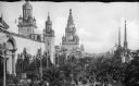
| Description: | Elevated view of crowd on Palm Avenue at the Panama-Pacific Exposition in San Fransisco, California, 1915. Several ornate buildings can be seen near the cr... |

| Date: | 1915 |
|---|---|
| Description: | The Municipal Building, which holds the City Hall and Public Library. |

| Date: | 1915 |
|---|---|
| Description: | Advertisement reads: "Castle-Pierce Printing Company" and "Feb. 1915". Text on right reads: "The Heart of Oshkosh. This birds-eye view represents about one... |

| Date: | 1915 |
|---|---|
| Description: | This map shows roads, railroads, street railways, abandoned logging railroads, rural mail routes, telephone lines, schools, platted land, and state forest ... |

| Date: | 1915 |
|---|---|
| Description: | This map includes automobile routes through the state as well as routes in parts of Iowa, Michigan and Minnesota. Cities, counties, Lake Michigan, Lake Sup... |

| Date: | 1915 |
|---|---|
| Description: | This map displays various automobile routes through the state of Wisconsin and parts of Illinois, Iowa, Minnesota, and Michigan. Cities, counties, Lake Mic... |

| Date: | 1915 |
|---|---|
| Description: | This map shows highways in the state and includes in the left bottom margin information on the population to be served by proposed roads. There are handwri... |
If you didn't find the material you searched for, our Library Reference Staff can help.
Call our reference desk at 608-264-6535 or email us at: