 Filter: Categories of Wisconsin Historical Images
Filter: FULL_DATE of 1915
Filter: Subject of superior, lake
Filter: Categories of Wisconsin Historical Images
Filter: FULL_DATE of 1915
Filter: Subject of superior, lake
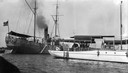
| Date: | 1915 |
|---|---|
| Description: | "Zenya" boat, owned by the Hull family, docked next to a Coast Guard vessel in La Pointe. |
| Date: | 1915 |
|---|---|
| Description: | Two women aboard the Hull family boat, the "Lizzie W.," while it is tied to shore at one of the Apostle Islands. |

| Date: | 1915 |
|---|---|
| Description: | Bird's-eye view of Superior, Wisconsin, and Duluth, Minnesota on opposite shore of Lake Superior. |

| Date: | 1915 |
|---|---|
| Description: | Elevated view of the harbor. Caption reads: "The Harbor, Superior, Wis." |
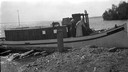
| Date: | 1915 |
|---|---|
| Description: | Building, boats, and fish net drying reels on South Twin Island in the Apostle Islands archipelago. |
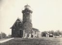
| Date: | 1915 |
|---|---|
| Description: | Sand Island Lighthouse on Apostle Island, Lake Superior. Lighthouse keeper and family are posing in the front of the building. |
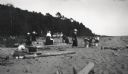
| Date: | 1915 |
|---|---|
| Description: | Picnic on beach of one of the Apostle Islands, Lake Superior. Image includes Mrs. Chute, Mrs. Webb., Mrs. Hull, H.W. Rogers and Mr. Chute. |
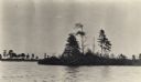
| Date: | 1915 |
|---|---|
| Description: | Trees on the eastern shoreline of Madeline Island near Big Bay. |

| Date: | 1915 |
|---|---|
| Description: | A map showing the location of post offices in Wisconsin and Michigan that were in operation as of April, 1915, along with the mail routes in use as well as... |

| Date: | 1915 |
|---|---|
| Description: | This map shows the extent of Wisconsin and pre-Wisconsin drift. The bottom left of the map includes a map categorizing the colors used into geologic period... |

| Date: | 1915 |
|---|---|
| Description: | This map includes automobile routes through the state as well as routes in parts of Iowa, Michigan and Minnesota. Cities, counties, Lake Michigan, Lake Sup... |

| Date: | 1915 |
|---|---|
| Description: | This map displays various automobile routes through the state of Wisconsin and parts of Illinois, Iowa, Minnesota, and Michigan. Cities, counties, Lake Mic... |
If you didn't find the material you searched for, our Library Reference Staff can help.
Call our reference desk at 608-264-6535 or email us at: