 Filter: Categories of Wisconsin Historical Images
Filter: FULL_DATE of 1915
Filter: Subject of streets
Filter: Categories of Wisconsin Historical Images
Filter: FULL_DATE of 1915
Filter: Subject of streets

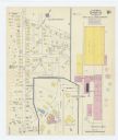
| Date: | 1915 |
|---|---|
| Description: | This map shows wards, railroads, street railways, streets, lot and block numbers, parks, and hospitals. Also included are manuscript annotations of points ... |

| Date: | 1915 |
|---|---|
| Description: | This manuscript blueprint map oriented with north to the upper right. The map includes street names, certifications, and registration. Streets left to righ... |
| Date: | 1915 |
|---|---|
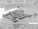
| Description: | Detailed drawing of an elevated view of the building layout at Whitman & Barnes Mfg. Co. in West Pullman, Chicago, Illinois. |

| Date: | 1915 |
|---|---|
| Description: | View from street of a dealership. On the left side of the building is a railroad car which is near the loading dock. |

| Date: | 1915 |
|---|---|
| Description: | Photographic postcard view down unpaved Washington Avenue. A clock on the sidewalk on the left is in front of a musical instrument shop. Snow is on the gro... |

| Date: | 1915 |
|---|---|
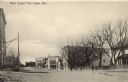
| Description: | View across snowy street towards the 200 block of State Street, the north side. On the corner at number 235 is the Badger Cigar Pipes and Tobacco store. Mo... |
| Date: | 1915 |
|---|---|
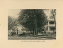
| Description: | Sepia-toned view down unpaved Main Street. Buildings, dwellings and trees are lining the street. Four men are standing in the street near a fence in the ce... |
| Date: | 1915 |
|---|---|
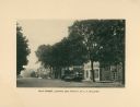
| Description: | A view down Main Street looking east from the Y.M.C.A. building. |
| Date: | 1915 |
|---|---|
| Description: | A view of Lake Street, looking West from Broad Street. Hotel Lane is on the right side, and several automobiles are parked backed-up to the curb in front. |
| Date: | 1915 |
|---|---|
| Description: | A Sanborn map of a portion of Janesville, including the Rock River Sugar Company. |

| Date: | 1915 |
|---|---|
| Description: | Color illustration of of a central street scene. A horse and wagon, automobile and streetcar in the street. A drug store in the lower left. A cigar store i... |
| Date: | 1915 |
|---|---|
| Description: | Three Austrian soldiers walking past a damaged building in Valjevo, Serbia. |
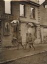
| Date: | 1915 |
|---|---|
| Description: | Soldiers and officers are posing in front of the destroyed Customs House in Sabac, Serbia. |
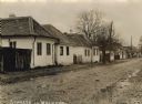
| Date: | 1915 |
|---|---|
| Description: | Houses along a street in Valjevo, Serbia in World War I. |

| Date: | 1915 |
|---|---|
| Description: | The house at 115 Ely Place, once owned by C.E. Buell. |

| Date: | 1915 |
|---|---|
| Description: | Serbian populace, chased out of their homes by their own troops, fleeing from town to town. Here passing through Sabac in Serbia. |

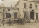
| Date: | 1915 |
|---|---|
| Description: | Elevated view of an Austrian patrol riding through the streets of Sabac in Serbia. |

| Date: | 1915 |
|---|---|
| Description: | Field Marshal Baron Franz Conrad von Hötzendorf was the Chief of Staff of the Austro-Hungarian army from 1910 to 1917. |

| Date: | 1915 |
|---|---|
| Description: | U.S. Army officers — Captain McIntire and Major Ford. Military attachés from neutral countries, such as the United States, would have received permission t... |

| Date: | 1915 |
|---|---|
| Description: | A Viennese errand boy pulling a wounded soldier in a cart to his destination. |
If you didn't find the material you searched for, our Library Reference Staff can help.
Call our reference desk at 608-264-6535 or email us at: