 Filter: Categories of Wisconsin Historical Images
Filter: FULL_DATE of 1915
Filter: Subject of streams
Filter: Categories of Wisconsin Historical Images
Filter: FULL_DATE of 1915
Filter: Subject of streams

| Date: | 1915 |
|---|---|
| Description: | A young woman sits on a log which lies over a stream bed in a wooded area. |
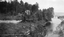
| Date: | 1915 |
|---|---|
| Description: | Elevated view of a two-story house sited beside Shivering Sands Creek where it enters Lake Michigan. There is a rustic footbridge over the stream close to ... |

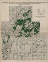
| Date: | 1915 |
|---|---|
| Description: | This 1915 map of Lincoln County, Wisconsin, shows the township and range grid, towns, cities and villages, lakes and streams, residences, churches, school ... |

| Date: | 1915 |
|---|---|
| Description: | This 1915 map covers portions of Barron, Chippewa, and Rusk counties in Wisconsin. Shown are the township and range grid, sections, cities and villages, ra... |
| Date: | 1915 |
|---|---|
| Description: | This early 20th century map highlights the land for sale by the American Immigration Company, Chippewa Falls, Wisconsin, in the towns of Cable, Drummond, G... |
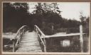
| Date: | 1915 |
|---|---|
| Description: | A rustic foot bridge over Fish Creek connects Peninsula State Park (foreground) with the village of Fish Creek. The Vits house is at the right end of the b... |
| Date: | 1915 |
|---|---|
| Description: | View from the Vits property, looking east, across a rustic foot bridge over Fish Creek leading to Peninsula State Park. A dachshund rests in the middle of ... |
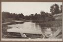
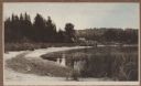
| Date: | 1915 |
|---|---|
| Description: | A wooden boat forms the foreground of a view of a stream, probably Shivering Sands Creek, and wetlands, with a sand dune on the right. |

| Date: | 1915 |
|---|---|
| Description: | This 1915 map covers the section of the Wisconsin River in southern Adams, southeastern Juneau, northeastern Sauk, and northwestern Columbia counties. A po... |
If you didn't find the material you searched for, our Library Reference Staff can help.
Call our reference desk at 608-264-6535 or email us at: