 Filter: Categories of Wisconsin Historical Images
Filter: FULL_DATE of 1915
Filter: Subject of rivers
Filter: Subject of land
Filter: Categories of Wisconsin Historical Images
Filter: FULL_DATE of 1915
Filter: Subject of rivers
Filter: Subject of land
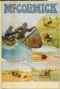
| Date: | 1915 |
|---|---|
| Description: | Advertising poster for McCormick brand farm implements featuring two men paddling a canoe in rough water. Also includes color illustrations of a reaper, ha... |

| Date: | 1915 |
|---|---|
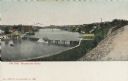
| Description: | Bird's-eye view of Superior, Wisconsin, and Duluth, Minnesota on opposite shore of Lake Superior. |
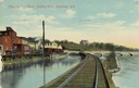
| Date: | 1915 |
|---|---|
| Description: | View of the Fox River, looking east, from railroad tracks. There is a bridge further down on the right. Buildings line the shoreline on the left, and a lar... |
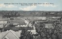
| Date: | 1915 |
|---|---|
| Description: | Elevated view from the Court House. Hills are in the distance. Caption reads: "Bird's-eye View from Court House, showing Main Street and Black River, Black... |

| Date: | 1915 |
|---|---|
| Description: | Elevated view of the St. Croix River, Northwest Railroad, bridge, and part of the town of Hudson. Caption reads: "Hudson, Wis. Bird's Eye View, showing St.... |
| Date: | 1915 |
|---|---|
| Description: | Burkhardt Milling and Electric Power Co., built in 1914. |
| Date: | 1915 |
|---|---|
| Description: | Burkhardt Milling and Electric Power Co., built in 1914. |
| Date: | 1915 |
|---|---|
| Description: | Elevated view of dam on river. A bridge is in the background. Houses are on top of the hill on the right side. Caption reads: "The Dam, Milwaukee River." |

| Date: | 1915 |
|---|---|
| Description: | Plat map of Polk township in Washington County. |

| Date: | 1915 |
|---|---|
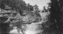
| Description: | Five men in suits pose near the Roaring River in a canyon. |

| Date: | 1915 |
|---|---|
| Description: | A map of Wisconsin that shows 1,900 miles of national highways proposed for the state. The map also includes the names and locations of towns and cities th... |

| Date: | 1915 |
|---|---|
| Description: | A map showing the location of post offices in Wisconsin and Michigan that were in operation as of April, 1915, along with the mail routes in use as well as... |

| Date: | 1915 |
|---|---|
| Description: | This 1915 map shows railroads, wagon roads, trails, creeks, rivers, lakes, and trout streams in Oneida and Lincoln counties within a 12 mile radius of Rhin... |

| Date: | 1915 |
|---|---|
| Description: | Shows land ownership, roads, railroads, and highways. Includes significant manuscript annotations and table of Wisconsin Highway Commission members. "The r... |
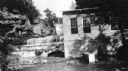
| Date: | 1915 |
|---|---|
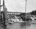
| Description: | Wooden dam on a river. Trees and hills are in the background. |

| Date: | 1915 |
|---|---|
| Description: | This map shows the extent of Wisconsin and pre-Wisconsin drift. The bottom left of the map includes a map categorizing the colors used into geologic period... |

| Date: | 1915 |
|---|---|
| Description: | View of the Upper Dam on the Rock River near Mayville. A church is on the hill on the left. Caption reads: "Upper Dam, Mayville, Wis." |

| Date: | 1915 |
|---|---|
| Description: | A composite plat map of the towns of Mequon, Saukville, Belgium, Fort Washington, and Fredonia. |
If you didn't find the material you searched for, our Library Reference Staff can help.
Call our reference desk at 608-264-6535 or email us at:
