Filter: Categories of Wisconsin Historical Images
Filter: FULL_DATE of 1915
Filter: Subject of rivers
Filter: Subject of human settlements
Filter: Categories of Wisconsin Historical Images
Filter: FULL_DATE of 1915
Filter: Subject of rivers
Filter: Subject of human settlements

| Date: | 1915 |
|---|---|
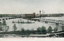
| Description: | Bird's-eye view of Superior, Wisconsin, and Duluth, Minnesota on opposite shore of Lake Superior. |
| Date: | 1915 |
|---|---|
| Description: | View of the Fox River, looking east, from railroad tracks. There is a bridge further down on the right. Buildings line the shoreline on the left, and a lar... |
| Date: | 1915 |
|---|---|
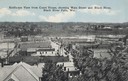
| Description: | Elevated view from the Court House. Hills are in the distance. Caption reads: "Bird's-eye View from Court House, showing Main Street and Black River, Black... |
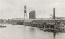
| Date: | 1915 |
|---|---|
| Description: | Elevated view of government locks and factory district on the Fox River. Caption reads: "Government Locks and Factory District, De Pere, Wis." |
| Date: | 1915 |
|---|---|
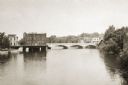
| Description: | View across water towards the Main Street Bridge over the Rock River. |
| Date: | 1915 |
|---|---|
| Description: | Distant view of Fort Atkinson from the shoreline of the Rock River. Caption reads: "Fort Atkinson, Wis., from Rock River." |

| Date: | 1915 |
|---|---|
| Description: | Elevated view of the St. Croix River, Northwest Railroad, bridge, and part of the town of Hudson. Caption reads: "Hudson, Wis. Bird's Eye View, showing St.... |
| Date: | 1915 |
|---|---|
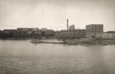
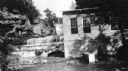
| Description: | Burkhardt Milling and Electric Power Co., built in 1914. |
| Date: | 1915 |
|---|---|
| Description: | Burkhardt Milling and Electric Power Co., built in 1914. |
| Date: | 1915 |
|---|---|
| Description: | Elevated view of the Marathon Paper Mills from across the river. Caption reads: "Scene at the Marathon Paper Mills, Wausau, Wis." |

| Date: | 1915 |
|---|---|
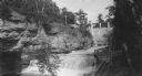
| Description: | A dam stretching acrossed the Rock River near the Empire mills, later the Globe mills. |

| Date: | 1915 |
|---|---|
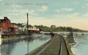
| Description: | The Portage canal looking east from the Canal Bridge. Boats are lines up along the shoreline on the left near a long building. |

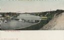
| Date: | 1915 |
|---|---|
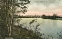
| Description: | An elevated view of the town and river. |

| Date: | 1915 |
|---|---|
| Description: | Advertisement reads: "Castle-Pierce Printing Company" and "Feb. 1915". Text on right reads: "The Heart of Oshkosh. This birds-eye view represents about one... |

| Date: | 1915 |
|---|---|
| Description: | Wisconsin Street looking east from the River Bridge. Caption reads: "Wisconsin St. East from River, Milwaukee, Wis." |

| Date: | 1915 |
|---|---|
| Description: | View across river toward Wisconsin Street and the River Bridge. Caption reads: "Wisconsin Street, East from River Bridge, Milwaukee, Wis." |
| Date: | 1915 |
|---|---|
| Description: | Elevated view of dam on river. A bridge is in the background. Houses are on top of the hill on the right side. Caption reads: "The Dam, Milwaukee River." |

| Date: | 1915 |
|---|---|
| Description: | Plat map of Polk township in Washington County. |

| Date: | 1915 |
|---|---|
| Description: | A map of Wisconsin that shows 1,900 miles of national highways proposed for the state. The map also includes the names and locations of towns and cities th... |
If you didn't find the material you searched for, our Library Reference Staff can help.
Call our reference desk at 608-264-6535 or email us at: