 Filter: Categories of Wisconsin Historical Images
Filter: FULL_DATE of 1915
Filter: Subject of mississippi river
Filter: Subject of cities and towns
Filter: Categories of Wisconsin Historical Images
Filter: FULL_DATE of 1915
Filter: Subject of mississippi river
Filter: Subject of cities and towns

| Date: | 1915 |
|---|---|
| Description: | Elevated view of Pontoon Bridge. Caption reads: "Largest Pontoon Bridge in the U.S. Scene at the Tri Cities, North and South McGergor and Prairie du Chien.... |

| Date: | 1915 |
|---|---|
| Description: | A map showing the location of post offices in Wisconsin and Michigan that were in operation as of April, 1915, along with the mail routes in use as well as... |
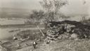
| Date: | 1915 |
|---|---|
| Description: | Elevated view of the Mississippi River from a bluff. There is a farm and other houses along the shoreline, and in the foreground a boy stands on the bluff ... |

| Date: | 1915 |
|---|---|
| Description: | This map shows the extent of Wisconsin and pre-Wisconsin drift. The bottom left of the map includes a map categorizing the colors used into geologic period... |

| Date: | 1915 |
|---|---|
| Description: | This map includes automobile routes through the state as well as routes in parts of Iowa, Michigan and Minnesota. Cities, counties, Lake Michigan, Lake Sup... |

| Date: | 1915 |
|---|---|
| Description: | This map displays various automobile routes through the state of Wisconsin and parts of Illinois, Iowa, Minnesota, and Michigan. Cities, counties, Lake Mic... |
If you didn't find the material you searched for, our Library Reference Staff can help.
Call our reference desk at 608-264-6535 or email us at: